Morge (Isere)
|
Morge Canal de la Morge |
||
|
Confluence of the Morge (left) and Brassière du Rebassat (right) |
||
| Data | ||
| Water code | FR : W31-0400 , FR : W3205002 | |
| location | France , Auvergne-Rhône-Alpes region | |
| River system | Rhône | |
| Drain over | Isère → Rhône → Mediterranean | |
| source | in the municipality of Saint-Aupre 45 ° 25 ′ 31 ″ N , 5 ° 40 ′ 9 ″ E |
|
| Source height | approx. 810 m | |
| muzzle | in the municipality of Poliénas in the Isère coordinates: 45 ° 13 ′ 43 ″ N , 5 ° 29 ′ 6 ″ E 45 ° 13 ′ 43 ″ N , 5 ° 29 ′ 6 ″ E |
|
| Mouth height | approx. 180 m | |
| Height difference | approx. 630 m | |
| Bottom slope | approx. 18 ‰ | |
| length | 35 km | |
| Right tributaries | Fure | |
| Medium-sized cities | Voiron | |
| Small towns | Moirans | |
|
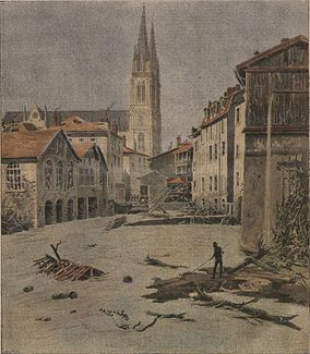
Flood in Voiron in 1897 |
||
The Morge is a river in France that runs in the Isère department in the Auvergne-Rhône-Alpes region . It rises in the municipality of Saint-Aupre in the Chartreuse Regional Nature Park , generally drains in a south-westerly direction and after 35 kilometers flows into the Isère as a right tributary in the municipality of Poliénas . For the last eight kilometers, the Morge runs under the name Canal de la Morge at a short distance between the A49 motorway and the Isère river.
Places on the river
(Order in flow direction)
Individual evidence
- ↑ Source geoportail.gouv.fr
- ↑ estuary geoportail.gouv.fr
- ↑ Water information system Service d'Administration National des Données et Référentiels sur l'Eau (French) ( notes ), in combination with the water information system Service d'Administration National des Données et Référentiels sur l'Eau (French) ( notes ) accessed on 29 May 2014, rounded to full kilometers

