Mtwara (district)
| Mtwara district | |
|---|---|
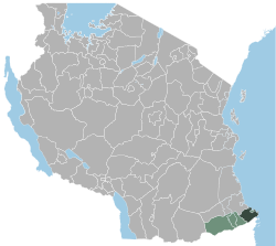
 Location of the Mtwara district in Tanzania |
|
| Basic data | |
| Country | Tanzania |
| region | Mtwara |
| surface | 3760 km² |
| Residents | 336,302 (2012) |
| density | 89 inhabitants per km² |
| ISO 3166-2 | TZ-17 |
Coordinates: 10 ° 19 ′ S , 40 ° 9 ′ E
Mtwara is a district in the Tanzanian region of Mtwara with the capital Mtwara . It borders on the Lindi region to the north, the Pacific Ocean to the east, Mozambique to the south and the Tandahimba district to the west .
geography
The district is located in the east of the Mtwara region and has an area of 3760 square kilometers and 336,302 inhabitants (as of 2012). The land rises from the east, the coast of the Indian Ocean, to the west on the Makonde plateau , which is 350 meters above sea level. The precipitation averaging 800 to 900 millimeters per year falls mainly in the months of November to May. In this rainy season it is also cooler with temperatures around 23 degrees Celsius. The dry season from June to October is much warmer at 30 degrees Celsius.
history
The word Mtwara is derived from the Kannada word "carry".
Administrative division
The district consists of the two councils Mtwara DC (rural district) and Mtwara-Mikindani MC (municipal district). The rural district consists of 28, the city district of 15 municipalities (wards):
Mtwara DC
|
Mtwara MMC
|
populationMainly Makonde live in the district, Mwela, Yao and Makua also live in the city . The population increased from 2002 to 2012 in the rural district by twelve and in the city district by eighteen percent. The proportion of illiterate people over five was 44 percent in rural areas and 20 percent in cities (as of 2012). Facilities and services |
 |
- Education: In 2012, 31 percent of the rural population and 48 percent of the urban population of those over five had completed schooling. Around a tenth had dropped out of school and a quarter were just going to school. The proportion of the population who had never attended school was 38 percent in rural areas and 27 percent in cities.
- Health: There are three health centers and 24 pharmacies in the city of Mtwara.
- Water: A third of the rural population had access to good water, but more than 90 percent of the urban population. In rural areas, 22 percent obtained their supplies from shaft wells, 23 percent from rivers or lakes, eleven percent collected rainwater and around ten percent had access to an unsecured spring (as of 2012).
Economy and Infrastructure
Mtwara is one of the poorest districts in Tanzania. The most important branch of the economy is agriculture, on the coast fishing is gaining in importance.
- Agriculture: Agriculture generates three quarters of the district's income. The average size of the farms is between one and a half and three and a half hectares. Millet, cashew nuts, peanuts, corn, rice, cassava, legumes and coconuts are mainly grown. In the countryside, 96 percent of the farms keep livestock, mainly poultry, but also goats and cattle.
- Fishing: There are 27 fishing villages on the coast. The growing sector employs 6,000 people (as of 2014).
- Industry and Commerce: There are only small businesses in the district that employ a total of 8,000 workers. Activities include carpentry, brick making, tailoring and construction.
- Roads: The only trunk road leads north from the town of Mtwara, along the coast, to Lindi .
- Shipping: Around a hundred ships are handled in the small port of Mtwara every year.
Web links
Individual evidence
- ↑ Category publications | Mtwara Region Socio-Economic Profile 2015. (pdf) Mtwara Region, March 2018, pp. 4–5 , accessed on November 16, 2019 .
- ↑ Maps for the World, Map 500k - xc37-4. Russian Army Map, accessed November 17, 2019 (Russian).
- ↑ a b History | Mtwara District Council. Tanzania, Regional Administration and Local Government, accessed November 17, 2019 (Swahili).
- ↑ Tanzania: Coastal Tanzania (Districts and Wards) - Population Statistics, Charts and Map. Retrieved November 17, 2019 .
- ↑ Category publications | Mtwara Region Socio-Economic Profile 2015. (pdf) March 2018, p. 6 , accessed on November 17, 2019 .
- ↑ Tanzania Regional Profiles, 09. Mtwara Regional Profile. (pdf) The United Republic of Tanzania, pp. 15, 71 , accessed on November 16, 2019 .
- ↑ Tanzania Regional Profiles, 09. Mtwara Regional Profile. (pdf) The United Republic of Tanzania, p. 78 , accessed on November 16, 2019 .
- ↑ Health Services | Nanyamba Town Council. Tanzania Regional Administration and Local Government, accessed November 17, 2019 (Swahili).
- ↑ Tanzania Regional Profiles, 09. Mtwara Regional Profile. (pdf) The United Republic of Tanzania, p. 112 , accessed November 16, 2019 .
- ↑ a b c d Category publications | Strategic plan. (pdf) Mtwara District Council, November 14, 2017, pp. 2–3 , accessed November 17, 2019 .
- ↑ Tanzania Regional Profiles, 09. Mtwara Regional Profile. (pdf) The United Republic of Tanzania, pp. 128, 131 , accessed on November 16, 2019 .
- ^ Trunk Roads Network. (pdf) Retrieved November 18, 2019 .
- ↑ National Bureau of Statistics, Tanzania in Figures 2018. (pdf) The United Republic of Tanzania, June 2019, pp. 66–67 , accessed on November 14, 2019 .


