Municipio Champotón
| Champotón | ||
|---|---|---|

|
||
| Symbols | ||
|
||
| Basic data | ||
| Country | Mexico | |
| State | Campeche | |
| Seat | Champotón | |
| surface | 6,876.3 km² | |
| Residents | 83,021 (2010) | |
| density | 12.1 inhabitants per km² | |
| founding | 1915 | |
| Website | www.champoton.gob.mx | |
| INEGI no. | 04004 | |
| politics | ||
| Presidente municipal | Daniel Martin León Cruz | |
Coordinates: 19 ° 20 ′ N , 90 ° 40 ′ W
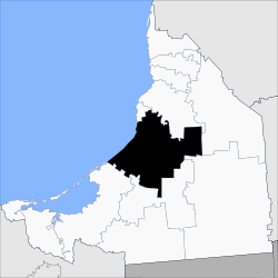
Champotón is a municipality in the Mexican state of Campeche . The municipality has 83,021 inhabitants (2010 census) and is 6876 km² in size. The administrative seat and largest town of the municipality is the Champotón of the same name .
geography
The municipality of Champotón is located in the center of the Mexican state of Campeche between sea level and just over 100 m . About 90% of it belongs to the physiographic province of the Yucatán peninsula and about 10% to the southern coastal plain of the Gulf , 97% to the hydrographic region of Yucatán Oeste and just under 3% to the Grijalva - Usumacinta region . The geology of the municipality is determined by 65% limestone and 27% alluvion ; the predominant soil types are Leptosol (39%), Vertisol (35%) and Phaeozem (15%). Almost three quarters of the community area is forested, around 15% is pasture land.
The municipality of Champotón borders the municipalities of Campeche , Hopelchén , Calakmul , Escárcega and Carmen as well as the Gulf of Mexico .
population
In the 2010 census, 83,021 people were counted in 21,106 residential units in the municipality. Of these, 8,211 people were registered as speakers of an indigenous language , including 4,218 speakers of Mayathan , 1,328 speakers of Kanjobal and 620 speakers of Kekchí . A good twelve percent of the population were illiterate. 30,810 inhabitants were registered as economically active, of which approx. 77% were men or 2.9% were unemployed. Over 13% of the population lived in extreme poverty.
places
The municipality of Champotón includes 280 inhabited localidades , of which, in addition to the main town , Seybaplaya, Villa Madero, Santo Domingo Kesté, Carrillo Puerto, Sihochac and Ley Federal de Reforma Agraria are classified as urban by the INEGI . Twelve places had a population of over 1000 in the 2010 census, 217 places had fewer than 100 inhabitants. The biggest places are:
| place | Residents |
| Champotón | 30,881 |
| Seybaplaya | 8,711 |
| Villa Madero | 3,954 |
| Santo Domingo Kesté | 3,763 |
| Carrillo Puerto | 2,829 |
| Sihochac | 2,731 |
| Ley Federal de Reforma Agraria | 2,435 |
| Xbacab | 1,649 |
| San Pablo Pixtún | 1,498 |
| Maya Tecun I | 1,254 |
| Hool | 1,181 |
| La Joya | 1.007 |
| Maya Tecun II | 995 |
| Xkeulil | 991 |
| Miguel Colorado | 923 |
| Aquiles Serdán ( Chuiná ) | 896 |
| Cinco de Febrero | 844 |
| Ulumal | 833 |
Web links
- Enciclopedia de los Municipios y Delegaciones de México: Municipio Champotón (Spanish)
- INEGI : Datos Geográficos: Municipio Champotón (Spanish; PDF)

