Municipio Cuatro Cañadas
| Municipio Cuatro Cañadas | ||
|---|---|---|
| Basic data
|
||
| Residents (state) | 22,845 pop. (2012 census) | |
| Post Code | 07-1106 | |
| Telephone code | (+591) | |
| height | 260 m | |
| Coordinates | 17 ° 13 ′ S , 62 ° 12 ′ W | |
|
|
||
| politics
|
||
| Department | Santa Cruz | |
| province | Province of Ñuflo de Chavez | |
| Central place | Cuatro Cañadas | |
| climate | ||
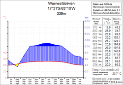
 Climate diagram Warnes |
||
The Municipio Cuatro Cañadas is a district in the Santa Cruz Department in the lowlands of the South American Andean state of Bolivia .
Location in the vicinity
The municipality Cuatro Cañadas is one of the six municipalities in the province of Ñuflo de Chávez . It borders on the municipality of Concepción in the north, on the municipality of San Julián in the northwest , on the province of Ignacio Warnes in the west, on the province of Andrés Ibáñez in the southwest , on the province of Chiquitos in the south, on the province of José Miguel de Velasco in the east , and in the northeast to the municipality of San Antonio de Lomerío .
The municipality is located between about 17 ° 01 'and 17 ° 32' south latitude and 61 ° 30 'and 62 ° 47' west longitude, its extension in north-south direction is up to 50 kilometers and in east-west direction up to 125 kilometers.
The central place of the district is the small town Cuatro Cañadas with 8,195 inhabitants ( 2012 census ) in the western part of the municipality.
geography
The municipality of Cuatro Cañadas is located in the Bolivian lowlands in the Chiquitania region , a colonization area between Santa Cruz and the Brazilian border. The region was covered by subtropical rainforest before colonization , but is now mostly cultivated land .
The mean average temperature of the region is just under 24 ° C (see Warnes climate diagram), the monthly values fluctuate between 20 ° C in June / July and 26 ° C from November to February. The annual precipitation is about 1300 mm, the monthly precipitation is productive and lies between 35 mm in August and 200 mm in January.
population
The population of the municipality has increased by about two and a half times over the past two decades:
- 1992 : 9,210 inhabitants ( census )
- 2001 : 17,574 inhabitants (census)
- 2012 : 22,845 inhabitants (census)
94.5 percent of the population speak Spanish , 42.1 percent speak Quechua , 1.2 percent Aymara , 0.7 percent Guaraní , and 1.7 percent speak other indigenous languages .
The infant mortality rate was 7.9 per cent ( 1992 declined slightly) to 7.8 percent in 2001, the literacy rate among the over six-year-olds of 84.9 percent ( in 1992 rose) to 88.9 percent.
65.9 percent of the population have no access to electricity , 20.7 percent live without sanitary facilities . ( 2001 )
55.2 percent of the 3,321 households have a radio, 30.6 percent a television, 54.8 percent a bicycle, 4.7 percent a motorcycle, 17.4 percent a car, 32.0 percent a refrigerator, and 3.4 percent Percent a phone. ( 2001 )
politics
Results of the elections for the municipal council ( concejales del municipio ) in the regional elections on April 4, 2010:
| electoral legitimate |
electoral participation |
valid votes | MAS-IPSP | UCS | ASIP | SOL | MSM | ||
|---|---|---|---|---|---|---|---|---|---|
| 6,831 | 5,412 | 4.114 | 2.129 | 779 | 716 | 311 | 179 | ||
| 79.2% | 76.0% | 51.8% | 18.9% | 17.4% | 7.6% | 4.4% |
structure
The municipality of Cuatro Cañadas is not in cantons ( cantones split).
Individual evidence
- ↑ Instituto Nacional de Estadística (INE) 1992
- ^ Instituto Nacional de Estadística (INE) 2001
- ↑ Instituto Nacional de Estadística (INE) 2012
- ↑ Acta de computo Nacional Electoral Departamentales, Municipales y Regional 2010
Web links
- Municipio Cuatro Cañadas - General Maps No. 71106
- Municipio Cuatro Cañadas - detailed map and population data (PDF; 1.6 MB) ( Spanish )
- Department Santa Cruz - Social data of the municipalities (PDF; 5 MB) ( Spanish )
