Municipio Tahua
| Municipio Tahua | ||
|---|---|---|
 Coqueza village overlooking the Salar de Uyuni |
||
| Basic data
|
||
| Population (state) - population density |
1700 inhabitants (2012 census) 1 inhabitant / km² |
|
| Post Code | 05-1402 | |
| Telephone code | (+591) | |
| surface | 3,272 km² | |
| height | 3700 m | |
| Coordinates | 20 ° 18 ′ S , 67 ° 24 ′ W | |
|
|
||
| politics
|
||
| Department | Potosí | |
| province | Daniel Campos Province | |
| Central place | Tahua | |
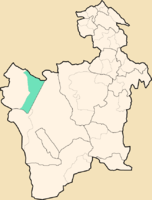
 Location of the Municipio Tahua in the Department of Potosí |
||
| climate | ||
 Climate diagram Llica |
||
The Municipio Tahua is a district in the Potosí Department in the highlands of the South American Andean state of Bolivia .
Location in the vicinity
The municipality of Tahua is one of two municipalities in the Daniel Campos province and consists of around 90 percent of the eastern part of the Salar de Uyuni salt lake . It borders the Municipio Llica to the west, the Nor Lípez province to the south, the Antonio Quijarro province to the east and the Oruro department to the north . It extends for about 150 kilometers in north-south and east-west directions.
geography
The Municipio Tahua is located on the Bolivian Altiplano between the Cordillera Occidental in the west and the Cordillera Central in the east.
The climate of the region is semi-arid and a typical daytime climate , in which the daily temperature fluctuations are more pronounced than the temperature differences over the course of the year (see climate diagram Llica).
The annual average temperature is around 6 ° C, the monthly averages in June / July are only 2 to 3 ° C and the summer values in January / February are just under 9 ° C. The annual precipitation is a low 150 mm, notable precipitation falls only in the months of January / February with 50 to 60 mm; from April to November there is a pronounced dry season with monthly precipitation close to 0 mm.
population
The population of the Municipio Tahua has increased only slightly in the past two decades:
- 1992 : 1,497 inhabitants ( census )
- 2001 : 2,166 inhabitants (census)
- 2010 : 1,700 inhabitants (census)
The population density of the municipality in the 2012 census was 0.5 inhabitants / km², the proportion of the population under 15 years of age is 46 percent, the proportion of the urban population is 0 percent.
The literacy rate for those over 19 is 91 percent, 98 percent for men and 84 percent for women. The most important idiom with a share of 77 percent is Spanish , 68 percent of the population speak Aymara . 87 percent of the population are Catholic, 8 percent Protestant.
The life expectancy of newborns is 55 years. 99 percent of the population have no access to electricity, and 99 percent also live without sanitation.
politics
Results of the elections for the municipal council ( concejales del municipio ) in the regional elections on April 4, 2010:
| electoral legitimate |
electoral participation |
valid votes | MAS-IPSP | FUC | MSM | ||
|---|---|---|---|---|---|---|---|
| 575 | 512 | 375 | 190 | 96 | 89 | ||
| 89.0% | 73.2% | 50.7% | 25.6% | 23.7% |
structure
The municipality is divided into the following cantons :
- 05-1401-01 Canton Tahua - 13 localities - 1,156 inhabitants ( 2012 census )
- 05-1401-02 Canton Ayque - 1 village - 59 inhabitants
- 05-1401-04 Canton Yonza - 6 villages - 325 inhabitants
- 05-1401-05 Canton of Cacoma - 2 villages - 102 inhabitants
- 05-1401-06 Canton Chiltaico - 1 village - 58 inhabitants
Localities in the municipality of Tahua
- Yonza Canton
- Yonza pop. 181
Individual evidence
- ^ Instituto Nacional de Estadística Bolivia (INE) 1992
- ↑ Instituto Nacional de Estadística Bolivia (INE) 2001
- ↑ Instituto Nacional de Estadística (INE) 2012 ( Memento of the original of July 22, 2011 in the Internet Archive ) Info: The archive link has been inserted automatically and has not yet been checked. Please check the original and archive link according to the instructions and then remove this notice.
- ↑ Acta de computo Nacional Electoral Departamentales, Municipales y Regional 2010
Web links
- Municipio Tahua - General Maps No. 51402
- Municipio Tahua - detailed map and population data (PDF; 855 kB) ( Spanish )
- Department Potosí - social data of the municipalities (PDF; 5.23 MB) ( Spanish )

