Municipio Tequisquiapan
| Tequisquiapan | ||
|---|---|---|

|
||
| Symbols | ||
|
||
| Basic data | ||
| Country | Mexico | |
| State | Querétaro | |
| Seat | Tequisquiapan | |
| surface | 370.7 km² | |
| Residents | 63,413 (2010) | |
| density | 171.1 inhabitants per km² | |
| INEGI no. | 22017 | |
| politics | ||
| Presidente municipal | Raúl Orihuela González | |
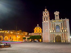
| The Parroquia de Santa María de la Asunción in Tequisquiapan | ||
Coordinates: 20 ° 30 ′ N , 99 ° 54 ′ W
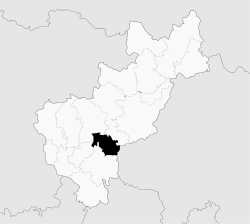
Tequisquiapan is a municipality in the Mexican state of Querétaro . The municipality covers an area of 370.7 km². In 2010, Tequisquiapan had a population of 63,413. The administrative seat and most populous place of the municipality is the Pueblo Mágico Tequisquiapan of the same name .
geography
The municipality of Tequisquiapan is located in the southern part of the state of Querétaro at an altitude between 1700 m and 2800 m . It belongs entirely to the physiographic province of the Sierra Volcánica Transversal and lies entirely in the catchment area of the Río Pánuco , whereby it drains into the Gulf of Mexico . Predominant rock types are Extrusivgesteine (including 31.5% pyroclastic , 16.7% rhyolite - Tuff , 9% Basalt ) 20.9% alluvium and 3.9% sediment . Soil type of 49% of the municipality is the Phaeozem , followed by 39% Vertisol and 6% Leptosol . A good 54% of the municipal area is used for arable farming, around 26% is covered by scrub, 13% is forested.
The Municipio Tequisquiapan borders the Municipios Colón , Ezequiel Montes , San Juan del Río and Pedro Escobedo, as well as the state of Hidalgo .
population
The 2010 census counted 63,413 people in 15,117 residential units in the municipality. 197 of them were registered as speakers of an indigenous language . Almost 7.7% of the population were illiterate. 25,872 inhabitants were registered as economically active, of which a good 65.5% were men and a good 4.3% were unemployed. 8.3% of the population lived in extreme poverty.
places
The Municipio Tequisquiapan comprises 102 inhabited localidades , of which the main town and San Nicolás, La Fuente, Fuentezuelas, Bordo Blanco and El Tejocote are classified as urban by the INEGI . Nine places had a population of over 2000 in the 2010 census, five other places had at least 500 inhabitants, 77 places had fewer than 100 inhabitants. The biggest places are:
| place | Residents |
| Tequisquiapan | 29,799 |
| San Nicolás | 5,576 |
| La Fuente | 4,272 |
| Fuentezuelas | 2,895 |
| Bordo Blanco | 2,709 |
| El Tejocote | 2,701 |
| Los Cerritos | 2,202 |
| San Jose de la Laja | 2.156 |
| La Tortuga | 2,029 |
| La Trinidad | 1,836 |
| Santillan | 1,281 |
| La Laja | 1,150 |
Web links
- Enciclopedia de los Municipios y Delegaciones de México: Tequisquiapan (Spanish)
- INEGI : Datos Geográficos: Tequisquiapan (Spanish; PDF)


