
Sample web


The model train is a street in Lübeck's old town .
location
The approximately 170 meter long model run is located on the southern edge of the old town island. It begins on Mühlenstraße , opposite the confluence of Straße An der Mauer and then runs in a slight curve in a south-westerly direction. At the choir of the cathedral which flows from the north Domkirchhof one; shortly afterwards the street describes a bend and continues between the Museum für Natur und Umwelt and the Mühlenteich until it meets and ends at the Mühlendamm at the archive of the Hanseatic City of Lübeck . While it is marked on the right-hand side, starting with the historicist main gymnasium and the wing of the school building of the former Higher Citizens 'School from 1881, which is now used by the OzD , on the left-hand side, on the south-facing waterfront properties to the Mühlenteich, Citizens' Palace of the 19th Century.
history
Today's model railway was originally just a narrow alley that ran on the inside of the city wall from the inner mill gate to the cathedral. A name was recorded late: in 1614 the street was referred to in the municipal building inventory as Munsterbahn , in 1852 the street name model railway , which is still valid today, was officially established.
The origin and meaning of the name have not yet been clarified. The view that Munsterbahn refers to the cathedral, i.e. the minster , is not tenable, as the minster was unknown as a synonym for a large church in Lübeck and there is only one documented mention of the initial term monasterium for the chapter house of the cathedral.
Another interpretation relates to the assumption that in the 17th century the citizen companies , i.e. the city militia , were patterned in the street . However, there is no evidence of this, and the narrow street along the city wall would have offered too little space for this purpose.
A third interpretation is based on the fact that there were horse stables on the model track , which belonged to a jug on the inner mill gate and which existed until 1860. The assumption is that horses were sampled in the street, that is, examined, which were then sold at the nearby horse market . However, there is no final certainty for this interpretation of the street name either.
Buildings
It was not until 1875 that the medieval city wall was torn down along the model line and the street was widened so that it took on its current dimensions. In the following years, palais-like Wilhelminian-style residential buildings were built on the south side of the model runway, which had been occupied by the Wall .
- Sample lane 3 , neo-renaissance house from 1878. The facade is decorated with terracottas from 1549 by Statius von Düren , which were originally located on Braunstraße 4 , which was demolished in 1878 . Because of these terracottas, the building is also known as the Statius-von-Düren-Haus in the Musterbahn .
- Musterbahn 6 , the Museum for Nature and Environment , built between 1959 and 1961 , into which the remains of the late Romanesque cathedral cloister from the middle of the 13th century and the façade of the late Gothic preacher's house built around 1460 are integrated.
- Model track 19 , neoclassical city palace from 1887 for the Lübeck businessman and Senator Emil Possehl

Main gym on the corner of Mühlenstraße and Musterbahn
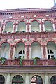
Statius-von-Düren-Haus, sample run 3

Statius von Düren House, detail

View over the mill pond to the garden side of the model run, around 1900
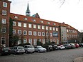
The model track at the Museum for Nature and Environment


literature
- W. Brehmer : The street names in the city of Lübeck and its suburbs. HG Rathgens, Lübeck 1889.
- Klaus J. Groth : World Heritage Lübeck - Listed Houses. Over 1000 portraits of the listed buildings in the old town. Listed alphabetically by streets. Verlag Schmidt-Römhild, Lübeck 1999, ISBN 3-7950-1231-7 .
- Max Hoffmann: The streets of the city of Lübeck. In: Journal of the Association for Lübeck History and Archeology. Jg. 11, 1909, ISSN 0083-5609 , pp. 215-292 (also special print: 1909).
Web links
Coordinates: 53 ° 51 '38.1 " N , 10 ° 41' 13.8" E