
Myjava (river)
| Myjava | ||
 |
||
| Data | ||
| location | Czech Republic , Slovakia | |
| River system | Danube | |
| Drain over | March → Danube → Black Sea | |
| source | west of the Čupec in the White Carpathians 48 ° 50 ′ 48 ″ N , 17 ° 36 ′ 34 ″ E |
|
| Source height | 675 m nm | |
| muzzle | near Kúty in the March coordinates: 48 ° 37 '44 " N , 16 ° 57' 30" E 48 ° 37 '44 " N , 16 ° 57' 30" E |
|
| Mouth height | 149 m nm | |
| Height difference | 526 m | |
| Bottom slope | 6.3 ‰ | |
| length | 84 km | |
| Catchment area | 745.12 km² | |
| Drain |
MQ |
3.04 m³ / s |
| Right tributaries | Teplica | |
The river Myjava ( German rarely Miawa ; Hungarian Miava ) rises in the White Carpathians at the foot of the Čupec ( 818.9 m ) until it flows into the March after about 80 kilometers .
The course of the river originates in the Czech Republic and after 600 meters crosses the border with Slovakia . It first turns south away from the White Carpathians. It flows through the municipality of Stará Myjava and on through the city of the same name Myjava . From this point on, the river also represents the geographical border between the White and Little Carpathians . Other larger towns on the Myjava are Jablonica , Senica and Šaštín-Stráže . The Myjava flows into the March near Kúty .

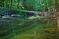
The Myjava flows into the March

Myjava in the Záhorie region
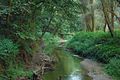
Myjava in the Záhorie region

Myjava in the Záhorie region
Myjava in the Záhorie region


