Northern Soswa
|
Northern Sosva Северная Сосьва (Severnaya Sosva) |
||
|
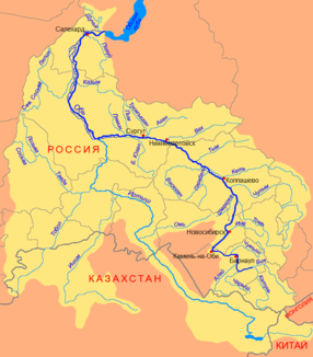
Course of the Northern Sosva (Северная Сосьва) in the western catchment area of the Ob |
||
| Data | ||
| Water code | RU : 15020200112115300023423 | |
| location | Khanty and Mansi Autonomous Okrug / Ugra ( Russia ) | |
| River system | If | |
| Drain over | Whether → Arctic Ocean | |
| confluence | of Big Soswa and Small Soswa 62 ° 2 ′ 53 ″ N , 60 ° 10 ′ 35 ″ E |
|
| Source height | 130 m | |
| muzzle | in the Malaja Ob coordinates: 64 ° 11 '23 " N , 65 ° 25' 55" E 64 ° 11 '23 " N , 65 ° 25' 55" E |
|
| Mouth height | 7 m | |
| Height difference | 123 m | |
| Bottom slope | 0.16 ‰ | |
| length | 754 km | |
| Catchment area | 98,300 km² | |
| Discharge at the Igrim A Eo gauge: 87,800 km² Location: 147 km above the estuary |
MQ 1958/1999 Mq 1958/1999 |
786 m³ / s 9 l / (s km²) |
| Outflow at the level at the mouth |
MQ |
860 m³ / s |
| Left tributaries | Lopsija, Njais, Volya, lyapin river , Wogulka | |
| Right tributaries | Tapsui, Wissim, Jalbynja, Little Soswa | |
| Small towns | Igrim , Beryosovo | |
| Navigable | 660 km | |
The 754 km long Northern Soswa ( Russian Северная Сосьва / Severnaja Soswa ) is a left tributary of the Ob in Western Siberia ( Russia ).
It is not to be confused with the Soswa , which has its origin not far from the sources of the Northern Soswa, but then flows in a south-westerly direction and represents the left source river of the Tawda .
course
The Northern Soswa arises at a height of about 130 m at the eastern foot of the Northern Urals from the source rivers Great Soswa (Bolshaya Soswa) from the left and Little Soswa (Malaya Soswa; not to be confused with the important tributary of the same name that flows into the lower central reaches) from the right . The two source rivers, each several dozen kilometers long, have their source at a height of about 600 m on the main ridge of the Urals, which rises just over 1000 meters in this section. On the western, European side of the Urals main ridge, the Pechora , the largest river in the northern European part of Russia, rises just a little further north .
The initially narrow river valley soon widens to a width of 40 kilometers. The river then flows through the western part of the West Siberian lowlands in wide arcs with predominantly east to north directions . For the last 100 kilometers, the Northern Soswa flows parallel to the Ob and, together with its arms, forms a floodplain about 50 kilometers wide, which can be largely flooded during the spring floods. On this section the two great arms of the Ob, Bolshaya Ob (“Big Ob”) and Malaya Ob (“Little Ob”), the Northern Sosva and its left tributary Vogulka are already connected by a series of arms (Laporskaya, Pyrsim, Waissowa ) before the Northern Soswa finally flows into the left arm of the Ob, Malaja Ob.
The Northern Soswa is over a kilometer wide in sections, over 500 m near the mouth and over 10 m deep; the flow velocity is 0.8 m / s. Its most important tributaries are Tapsui, Wissim, Jalbynja and Kleine Soswa (Malaja Soswa) from the right, as well as Lopsija, Njais, Wolja, Ljapin and Wogulka from the left.
The Northern Soswa flows along its entire length through the territory of the Khanty and Mansi / Ugra Autonomous Okrug .
Hydrography
The catchment area covers 98,300 km². In the vicinity of the mouth, the mean flow rate (MQ) is 860 m³ / s; at Igrim, 147 kilometers above, still 786 m³ / s with a minimum of 77.5 m³ / s in March and a maximum of 2653 m³ / s in June.
Northern Soswa freezes between late October / early November and late April / May, followed by floods that last until September.
Economy and Infrastructure
The Northern Soswa is navigable for 660 km from the village of Nyaksimwol, as is its tributaries Lyapin for 163 km and Little Soswa for 120 km.
Overall, the area through which the Northern Soswa flows is sparsely populated, but there are a number of smaller villages along its entire course. After natural gas deposits had been discovered in the middle and lower reaches of the river in the 1960s, the localities of Igrim and Berjosowo grew into larger settlements. There are no longer paved roads or railways in the area; the traffic is handled by inland shipping in summer and on ice roads in winter .
Berjosowo, located on the left bank of the lower reaches of the river at the confluence of the Vogulka, played an important historical role as the city of Berjosow since it was founded in 1593, first during the Russian colonization of Western Siberia, then until the 19th century as a place of exile , but lost its town charter in 1926.
Individual evidence
- ↑ a b Northern Sosva in the State Water Register of the Russian Federation (Russian)
- ↑ a b c Article Northern Soswa in the Great Soviet Encyclopedia (BSE) , 3rd edition 1969–1978 (Russian)
- ↑ a b Northern Soswa at the Igrim gauge - hydrographic data at R-ArcticNET
- ↑ List of Inland Waterways of the Russian Federation (confirmed by Order No. 1800 of the Government of the Russian Federation of December 19, 2002)
