Soswa
|
Sosva Сосьва |
||
|
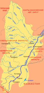
Course of the Soswa (Сосьва) in the northern catchment area of the Tobol |
||
| Data | ||
| Water code | RU : 14010502412111200009657 | |
| location | Sverdlovsk Oblast | |
| River system | If | |
| Drain over | Tavda → Tobol → Irtysh → Ob → Arctic Ocean | |
| confluence | from Big (Bolshaya) and Little (Malaja) Soswa | |
| muzzle | Confluence with Loswa to Tawda Coordinates: 59 ° 32 ′ 59 ″ N , 62 ° 20 ′ 4 ″ E 59 ° 32 ′ 59 ″ N , 62 ° 20 ′ 4 ″ E |
|
| Mouth height |
56 m
|
|
| length | 635 km | |
| Catchment area | 24,700 km² | |
| Discharge at the Soswa gauge (Sverdlovsk) A Eo : 22,100 km² Location: 140 km above the mouth |
NNQ (February 1939) MNQ 1938/1989 MQ 1938/1989 Mq 1938/1989 MHQ 1938/1989 HHQ (May 1957) |
4.9 m³ / s 17 m³ / s 123 m³ / s 5.6 l / (s km²) 453 m³ / s 1250 m³ / s |
| Right tributaries | Wagran , Turja , Kakwa , Lyalja | |
| Navigable | 333 km navigable | |
| Source river of the Tawda | ||
|
Soswa |
||
The 635 km long Soswa ( Russian Сосьва ) is the right source river of the Tawda in the eastern Urals and West Siberian lowlands ( Russia , Asia ).
geography
The Sosva arises on the eastern flank of the Ural main ridge of the two short (under 20 km) headwaters Great (Bolshaya) and Small (Malaya) Sosva, the roughly 600- 700 m altitude spring. First of all, it flows around several ridges of the Urals in the area of Deneschkin Kamen ( 1492 m ) in a narrow and steep valley - always on the territory of Sverdlovsk Oblast . The Soswa continues to flow in a south, later north-easterly direction through the western part of the West Siberian lowland to finally unite 12 km north of the urban-type settlement (and Rajon administrative center ) Gari with the Loswa to the Tawda (at 56 m above sea level ).
The catchment area of the Soswa covers 24,700 km². At the settlement of Soswa , about 140 river kilometers above the estuary, the mean water flow is 123 m³ / s (minimum in March with 17 m³ / s, maximum in June with 453 m³ / s). The water level in the middle and lower reaches fluctuates by up to 5–6 meters over the course of the year. In the lower reaches the river is about 80-100 m wide, 3 m deep, the flow velocity is 0.3 m / s. The main tributaries are, from right Wagran ( Вагран ) Turja ( Турья ) Kakwa ( Каква ) and Ljalja ( Ляля ).
The soswa freezes from early November to April.
In the area of the middle reaches a few kilometers west of the river, on the tributary Kakwa, the city of Serow . In the wide valley here running Railroads - Serov ivdel - Priobye and Serow - Alapayevsk , crossing the river in total at three places, as well as various local roads. Overall, compared to other rivers in the region, the valley of the Soswa is relatively densely populated for a large part of its course and has better transport connections.
The Soswa is navigable from the confluence of the Kakwa near Serow (333 km), but is currently only used as an inland waterway from the settlement of Soswa, 167 km above the mouth .
Individual evidence
- ↑ a b Article Soswa in the Great Soviet Encyclopedia (BSE) , 3rd edition 1969–1978 (Russian)
- ↑ a b Soswa in the State Water Register of the Russian Federation (Russian)
- ↑ Soswa at the Soswa gauge - hydrographic data at R-ArcticNET
- ↑ List of Inland Waterways of the Russian Federation (Government Ordinance of December 19, 2002, Russian)

