Tawda (river)
|
Tavda Tavda |
||
|
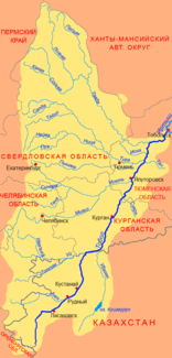
Course of the Tawda (Тавда) in the northwestern catchment area of the Tobol |
||
| Data | ||
| Water code | RU : 14010502512111200008628 | |
| location | Sverdlovsk Oblast , Tyumen Oblast ( Russia ) | |
| River system | If | |
| Drain over | Tobol → Irtysh → Ob → Arctic Ocean | |
| Union | from Loswa and Soswa 59 ° 32 ′ 59 ″ N , 62 ° 20 ′ 4 ″ E |
|
| Source height | 56 m | |
| muzzle | in the Tobol coordinates: 57 ° 47 ′ 56 " N , 67 ° 15 ′ 27" E 57 ° 47 ′ 56 " N , 67 ° 15 ′ 27" E |
|
| Mouth height | 38 m | |
| Height difference | 18 m | |
| Bottom slope | 0.03 ‰ | |
| length | 719 km | |
| Catchment area | 88,100 km² | |
| Discharge at the Tabory A Eo gauge : 74,200 km² Location: 372 km above the mouth |
MQ 1965/1989 Mq 1965/1989 |
410 m³ / s 5.5 l / (s km²) |
| Discharge at the Tawda A Eo gauge : 81,000 km² Location: 237 km above the mouth |
NNQ (1936 and 1956 (in March)) MNQ 1936/1956 MQ 1936/1956 Mq 1936/1956 MHQ 1936/1956 HHQ (1947 (in June)) |
18.6 m³ / s 35 m³ / s 440 m³ / s 5.4 l / (s km²) 1355 m³ / s 2730 m³ / s |
| Discharge at the Nizhnyaya Tawda A Eo gauge: 86,100 km² Location: 123 km above the mouth |
MQ 1967/1995 Mq 1967/1995 |
427 m³ / s 5 l / (s km²) |
| Left tributaries | Pelym | |
| Medium-sized cities | Tavda | |
The 719 km long Tawda ( Russian Тавда ) is a left tributary of the Tobol in the West Siberian lowlands .
The Tawda arises about 12 km north of the urban-type settlement and district administrative center Gari at 56 m above sea level. NN , from their source rivers Loswa (left) and Soswa (right) coming from the Urals . First, it flows - on the territory of Sverdlovsk Oblast - through the sparsely populated swamps of the western part of the West Siberian Plain, turns thereafter in southeastern up an easterly direction and finally ends at the village Batschelino , already in the Tyumen Oblast , in the Tobol (at 38 m above sea level ). The river flows in wide arches; in the middle reaches the right bank in particular is steep in places and up to over 20 m high.
The catchment area of the Tawda covers 88,100 km². At Tawda, 237 km above the mouth, the mean water flow is 440 m³ / s (minimum in March with 35 m³ / s, maximum in June with 1355 m³ / s). In the lower reaches the river is about 270 m wide, 4 m deep, the flow velocity is 0.4 m / s. The most important tributary from the left is the Pelym (Пелым).
The city of Tawda is located at the middle of the river . Here the river is reached by the Yekaterinburg - Tawda - Mezhduretschensky (Ustye-Acha) railway , a few kilometers above the mouth of the Tyumen - Tobolsk - Surgut line .
The Tavda freezes from early November to late April. It is navigable along its entire length.
The upper reaches of the Tawda is the spawning area of the white salmon ( Stenodus leucichthys ).
Individual evidence
- ↑ a b c Article Tawda in the Great Soviet Encyclopedia (BSE) , 3rd edition 1969–1978 (Russian)
- ↑ a b c Tawda in the State Water Register of the Russian Federation (Russian)
- ↑ Tawda at the Tabory gauge - hydrographic data from R-ArcticNET
- ↑ a b Tawda at the Tawda gauge - hydrographic data at R-ArcticNET
- ↑ Tawda at the Nizhnyaya Tawda gauge - hydrographic data from R-ArcticNET
- ↑ List of Inland Waterways of the Russian Federation (Government Ordinance of December 19, 2002, Russian)
