Loswa
|
Losva Лозьва |
||
|
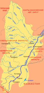
Course of the Loswa (Лозьва) in the northern catchment area of the Tobol |
||
| Data | ||
| Water code | RU : 14010502512111200008635 | |
| location | Sverdlovsk Oblast ( Russia ) | |
| River system | If | |
| Drain over | Tavda → Tobol → Irtysh → Ob → Arctic Ocean | |
| source | Pojassowy Kamen | |
| Source height | approx. 800 m | |
| muzzle | Confluence with the Soswa to the Tawda Coordinates: 59 ° 32 '59 " N , 62 ° 20' 4" E 59 ° 32 '59 " N , 62 ° 20' 4" E |
|
| Mouth height | 56 m | |
| Height difference | approx. 744 m | |
| Bottom slope | approx. 1.2 ‰ | |
| length | 637 km | |
| Catchment area | 17,800 km² | |
| Discharge at the gauge Schaburowo A Eo : 17,300 km² Location: 37 km above the mouth |
MNQ 1968/1981 MQ 1968/1981 Mq 1968/1981 MHQ 1968/1981 |
17.5 m³ / s 132 m³ / s 7.6 l / (s km²) 403 m³ / s |
| Right tributaries | Iwdel | |
| Source river of the Tawda | ||
The 637 km long Loswa ( Russian Лозьва ) is the left headwaters of the Tawda in the eastern Urals and West Siberian lowlands ( Russia , Asia ).
geography
The Lozva River originates on the eastern flank of here about 1200 m high northern Urals Comb Pojassowy Kamen ( Поясовый Камень ) at about 800 m above sea level. NN . Next it flows around - always on the territory of Sverdlovsk Oblast - first some eastern foothills of the Ural Mountains, then in a southeasterly direction through the sparsely populated swamps of the western part of the West Siberian Plain to finally 12 km north urban-type settlement (and Rajonverwaltungszentrum ) Gari with to unite the Soswa to the Tawda (at 56 m above sea level ).
The Loswa catchment area covers 17,800 km². At Schaburowo , about 35 km from the estuary, the mean water flow is 132 m³ / s (minimum in March with 17.5 m³ / s, maximum in June with 403 m³ / s). In the lower reaches the river is about 80 m wide, 2.5 m deep, the flow velocity is 0.5 m / s. The most important tributary is the Iwdel ( Ивдель ) from the right .
Loswa freezes from October / early November to late April / early May.
Economy and Transport
The town of Ivdel and the settlement of Polunochnoje lie a few kilometers to the west on the middle course of the river . The Serov - Ivdel - Polunochnoye railway approaches the river here and the Ivdel - Priobye line crosses it. The areas on the upper and lower reaches of the Loswa, on the other hand, are practically undeveloped in terms of traffic. However, there is a project to extend the route from Polunochnoje first along the Losva to the north, in order to finally reach the so-called Arctic Circle Railway near Labytnangi along the eastern edge of the Urals, west of the Ob .
The Loswa is navigable from the confluence of the Iwdel (near the town of Iwdel), but is currently only used as an inland waterway from the settlement of Ponil (at the confluence of the smaller tributary of the same name), 219 km above the confluence .
Parts of the Loswa catchment area have played an important role in the timber industry since the 1930s and 1950s, in which Gulag prisoners were initially used. For the removal of wood, narrow-gauge railway networks (750 mm) several hundred kilometers in length were built in the area, which is still practically street-free . The timber was transported on them for onward transport on the Loswa to the landing stages such as Chorpija, Novoschipitschny, Polunochnoje, Ponil or Nowy Wagil. During the Russian economic crisis of the 1990s, the timber industry came to a standstill in many places, and many narrow-gauge railways were shut down or dismantled.
Individual evidence
- ↑ a b c Article Loswa in the Great Soviet Encyclopedia (BSE) , 3rd edition 1969–1978 (Russian)
- ↑ a b Loswa in the State Water Directory of the Russian Federation (Russian)
- ↑ a b Loswa at the Schaburowo gauge - hydrographic data at R-ArcticNET
- ↑ List of Inland Waterways of the Russian Federation (Government Ordinance of December 19, 2002, Russian)
