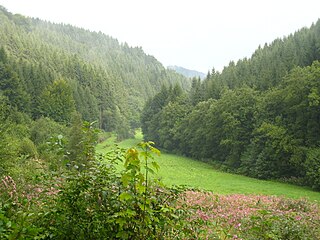
Takers Gorge
| Nahmerschlucht (with Hohenlimburg heights) | |||
|---|---|---|---|
| In the Nahmertal | |||
| Systematics according to | Handbook of the natural spatial structure of Germany | ||
| Greater region 1st order | Low mountain range threshold | ||
| Greater region 2nd order | Rhenish Slate Mountains | ||
| Main unit group | 33 → Süderbergland |
||
| About main unit | 336 → West Sauerland Oberland |
||
| 4th order region (main unit) |
336 1 → Märkisches Oberland |
||
| 5th order region | 336 1 .2 → Volme, Nahmer and Lennetal gorges |
||
| Natural space |
336 1 .21 → Nahmerschlucht (with Hohenlimburg heights) |
||
| Geographical location | |||
| Coordinates | 51 ° 21 '40 " N , 7 ° 34' 38" E | ||
|
|||
| local community | Hagen , Schalksmühle , Nachrodt-Wiblingwerde | ||
| state | North Rhine-Westphalia | ||
| Country | Germany | ||
The Nahmerschlucht (with Hohenlimburg heights) is a natural subunit with the order number 336 1 .21 of the Volme, Nahmer and Lennetal gorges (336 1 .2) within the Märkisches Oberland (336 1 ). According to the handbook of the natural spatial structure of Germany, it includes the mostly wooded valleys of the Nahmerbach and its tributaries (including the Mesekendahler Bach , Nimmerbach and Langenscheider Bach ) between Schalksmühle - Sonnenscheid and Hagen - Hohenlimburg, which are deeply cut into the Hülscheider plateaus (336 1 .3) . The Hohenlimburg Heights between Hagen- Delstern and Iserlohn - Genna with the town center of Hohenlimburg south of the Lenne and the valleys of the Milcherbach , Holthauser Bach , Wesselbach , Ferbecke , Selbecke and Ossenbecke are also located in the natural area.
The natural area lies on the northern edge of the Märkisches Oberland between Volme and Lenne and consists mainly of the wooded Nahmer Bachtal, which is cut up to 230 m deep into the Middle Devonian Grauwacken and slate , and its northern edge heights. The narrow valley with its steep slopes has a steep slope, which favored the settlement of proto- industrial hammer mills , which developed into a rich metalworking industry (e.g. wire drawing ).
The valleys of the Nahmerbach and its notch-shaped tributaries are usually shady and moist at the bottom and are natural locations for Sauerland ravine forests , but in their place mostly spruce and oak-beech cultures have emerged.
The Nahmer Bachtal flows in the north in the Oeger Lennetal near Hohenlimburg on the border with the Letmath limestone basin (337 2 .90). Two steep mountain noses, terraced up to a height of 200 m, flank the exit of the valley. On one is the Hohenlimburg Castle .

