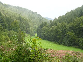
Volme, Nahmer and Lennetal gorges
| Volme, Nahmer and Lennetal gorges | |||
|---|---|---|---|
| In the Nahmertal | |||
| Systematics according to | Handbook of the natural spatial structure of Germany | ||
| Greater region 1st order | Low mountain range threshold | ||
| Greater region 2nd order | Rhenish Slate Mountains | ||
| Main unit group | 33 → Süderbergland |
||
| About main unit | 336 → West Sauerland Oberland |
||
| 4th order region (main unit) |
336 1 → Märkisches Oberland |
||
| Natural space |
336 1 .2 → Volme, Nahmer and Lennetal gorges |
||
| Geographical location | |||
| Coordinates | 51 ° 21 '40 " N , 7 ° 34' 38" E | ||
|
|||
| local community | Hagen | ||
| circle | Märkischer Kreis | ||
| state | North Rhine-Westphalia | ||
| Country | Germany | ||
The Volme, Nahmer and Lennetal gorges are a natural unit with the order number 336 1 .2 and, according to the handbook of the natural classification of Germany, comprise the main and side valleys of the Volme between Lüdenscheid - Oberbrügge and Hagen - Dahl (including the Hälvertal between Halver and Schalksmühle ), the Nahmerbach between the source at Schalksmühle- Sonnenscheid and Hagen- Hohenlimburg and the Lenne between Altena and Nachrodt-Wiblingwerde (including the Rahmedetal between Lüdenscheid and Altena and the Nettetal ). The city center of Hohenlimburg south of the Lenne is also in the natural area.
They are part of the Altenaer saddle (336 1 .0-5), which, beyond the strict hierarchical structure of the natural spaces, is an intermediate unit of six of the nine natural spaces (336 1 .0 to 336 1 .5) and thus two thirds of the area of the main unit Märkisches Oberland combined into a geological unit.
The gorges are cut deep into the hull plateau of the Märkisches Oberland (336 1 ) and are richly structured. The ravine valley systems have rugged slopes, often cut through the Remscheid-Altenaer saddle with numerous side notches and have steep slopes with mostly more than 20 ° inclination with sparse ground cover . The slope spurs are sharply cut and there is coarse debris at the feet of the slopes. Geologically, the gorges are mainly torn in the Grauwacken sandstones and slate of the Mühlenberg , Höbrecker and Hohenhofer layers of the Eifelium .
In the narrow valleys indigenous canyon forests grow, on the slopes oak forests or oak-beech mixed forests dominate .
The gorges differ climatically from the Hülscheid plateau (336 1 .3), the Breckerfeld plateau (336 1 .2), the Ihmerthoch plateau (336 1 .4) and the Halver-Lüdenscheider plateau (336 1 .6) in which they are incised. Compared to them, they are sheltered from the wind and milder, but also shady and humid and prone to ground fog , which arises after cold nights of radiation due to the cold air flowing in from above. The meandering valley floors are of different widths and in parts are strongly narrowed by diabase passages or quartzite banks. The bottom consists of gravel , which is covered with clay due to floods . The steep gradient of the flowing waters has favored the settlement of proto-industrial water mills and hammer mills , from which the rich ironmongery industry in the region developed.
In addition to the Volme, the Nahmerbach and the Lenne, the valleys of the following rivers are part of the natural area:
- Volme
- Linnepe below Oedenthal Castle
- Halver below the Heesfelder Mühle and Schlechtenbach / Bräumke below Mittelcarthausen
- Glör below the Glörtalsperre
- Diecke below the Rölveder mill
- Epscheider Bach with the source brooks Saure Epscheid , Süße Epscheid and the Langscheider Bach on the Krägeloher Berg
- Asmecke and Rumscheider Bach near Hagen-Dahl
- Hamperbach below the Hampermühle
- He took
- Lenne
- Biesenbergbach
- Rahmede below Lüdenscheid- Rathmecke
- Nice below Dahle
- Brachtenbecke
- Opperhusener Bach
- Kreinberger Bach
- Lasbeck Bach
- Ossenbecke
- Same corner
- Ferbecke
- Wesselbach
- Holthauser Bach
Natural structure
The Volme, Nahmer and Lennetal gorges are divided into the smaller natural areas as follows:
- 336 1 .2 Volme, Nahmer and Lennetal gorges
- 336 1 .20 Dahler Volmeschlucht
- 336 1 .21 Nahmerschlucht
- 336 1 .22 Altena Lenne Gorge

