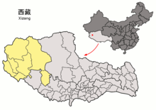
Ngari (District)
| Tibetan name |
|---|
|
Tibetan script :
མངའ་ རིས་ ས་ ཁུལ
|
|
Wylie transliteration : mnga 'ris sa khul
|
|
Official transcription of the PRCh : Ngari
|
|
THDL transcription : Ngari
|
|
Other spellings: -
|
| Chinese name |
|
Traditional :
阿里 地區
|
|
Simplified :
阿里 地区
|
|
Pinyin : Ālǐ Dìqū
|
Ngari ( Tibetan མངའ་ རིས་ ས་ ཁུལ transcription after Wylie : mnga 'ris sa khul ) is a Chinese administrative district in the northwest of the Tibet Autonomous Region . It has an area of 304,683 km² and approx. 80,000 inhabitants (2002). Ngari is one of the most sparsely populated areas in Tibet.
In the west, Ngari borders on Ladakh and Xinjiang , in the south on Spiti ( India ) and Nepal , in the east on the administrative district Xigazê (historical Tibetan province of Tsang ) and merges into the Changthang in the north . The international border is 1170 km long. Ngari is an average of 4500 m above sea level.
The four major rivers of the South Asian region have their source in the administrative district of Ngari, the Sengge Tsangpo ( Indus ) in the north, the Jarlung Tsangpo ( Brahmaputra ) in the east, the Langchen Tsangpo ( Satluj ) and the Mabja Tsangpo (an upper reaches of the Karnali , later Ghaghara ) in the west ) in the south.
The holy mountain Kailash (Gang Rinpoche) is in Ngari, the holy lake Manasarovar (Mapham Yutsho) in Burang County and the famous cultural and historical sites of the ancient kingdom of Guge (with Tsaparang and Tholing ) in Zanda County . A smaller, eastern part of the disputed Aksai Chin area is also in Ngari.
climate
The climate in Ngari is characterized by high daily and annual temperature differences and low rainfall. In the extreme southwest of the region in particular, there is extremely little rainfall. The landscape therefore takes on an almost desert-like character. In the administrative district capital of Ngari, the climate is somewhat more moderate, but temperatures of -40 degrees in winter and +25 degrees in summer are not uncommon. The lowest average temperature ever recorded was reached between 1966 and 1975 with -33.9 degrees in the large community Sênggê Zangbo, the highest average temperature was 17.3 degrees in July. Furthermore, Ngari is the sunniest region in Tibet with an average of 78% hours of sunshine per year. On average there are about 20 frostless days in Ngari.
|
Average monthly temperatures and rainfall for Sênggê Zangbo
Source: www.meteo365.de
|
||||||||||||||||||||||||||||||||||||||||||||||||||||||||||||||||||||||||||||||||||||||||||
Language and culture
Infrastructure
The most important road is the well-developed National Road 219 , sometimes also called the Xinjiang-Tibet Highway.
On July 1, 2010, Ngari-Günsa Airport started operations near the large community of Sênggê Zangbo .
Administrative division
Today's administrative district of Ngari only partially coincides with the historical province of Ngari. The historical kingdom Mangyül Gungthang and Ladakh were also assigned to Ngari in certain periods, but extended over regions that are not covered by the circles listed below. Today's Ngari administrative district is divided into seven districts. The seat of the administration is Sênggê Zangbo (Tib .: seng ge bzang po ; Chinese: 狮泉河 镇 , Pinyin: Shīquánhé Zhēn , Sengge Sangpo) on the upper reaches of the Indus in Gar district.
| Surname | Tibetan | Wylie | Chinese | Pinyin |
|---|---|---|---|---|
| Circle Gar | སྒར་ རྫོང་ | sgar rdzong | 噶尔 县 | Gá'ěr Xiàn |
| Burang County | སྤུ་ ཧྲེང་ རྫོང་ | spu hreng rdzong | 普兰 县 | Pǔlán Xiàn |
| circle Zanda | རྩ་ མདའ་ རྫོང་ | rtsa mda 'rdzong | 札达 县 | Zhádá Xiàn |
| District of Rutog | རུ་ ཐོག་ རྫོང་ | ru thog rdzong | 日 土 县 | Rìtǔ Xiàn |
| circle Ge'gyai | དགེ་ རྒྱས་ རྫོང་ | dge rgyas rdzong | 革 吉县 | Géjí Xiàn |
| Gêrzê district | སྒེར་ རྩེ་ རྫོང་ | sger rtse rdzong | 改 则 县 | Gǎizé Xiàn |
| circle Coqen | མཚོ་ ཆེན་ རྫོང་ | mtsho chen rdzong | 措 勤 县 | Cuòqín Xiàn |
