
Nieledwia
| Nieledwia | |||
|---|---|---|---|
 Help on coat of arms |
|
||
| Basic data | |||
| State : | Poland | ||
| Voivodeship : | Silesia | ||
| Powiat : | Żywiec | ||
| Gmina : | Milówka | ||
| Area : | 11.78 km² | ||
| Geographic location : | 49 ° 32 ' N , 19 ° 4' E | ||
| Residents : | 1035 (2009) | ||
| Telephone code : | (+48) 33 | ||
| License plate : | SZY | ||

Nieledwia is a village with a Schulzenamt in the Milówka municipality in the Powiat Żywiecki of the Silesian Voivodeship in Poland .
geography
The place lies on the brook Nieledwia in the Saybuscher Beskids ( Beskid Żywiecki ) .
The village has an area of 1178 hectares (12% of the rural parish).

View of the village
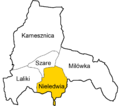
Village within the parish


history
The place was founded around the 16th century by the deforestation of Wallachians .
During the first partition of Poland in 1772 the village became part of the new Kingdom of Galicia and Lodomeria of the Habsburg Empire (from 1804).
In 1918, after the end of the First World War and the collapse of the Austro-Hungarian monarchy, Nieledwia came to Poland. This was only interrupted by the occupation of Poland by the Wehrmacht in World War II . It then belonged to the district of Saybusch in the administrative district of Katowice in the province of Silesia (since 1941 province of Upper Silesia ).
From 1975 to 1998 Nieledwia was part of the Bielsko-Biała Voivodeship .
Individual evidence
- ↑ a b c Gmina Milówka: SOŁECTWO NIELEDWIA: STATUT SOŁECTWA ( pl ) In: www.bip2.milowka.com.pl . March 27, 2009. Archived from the original on December 21, 2016. Info: The archive link was automatically inserted and not yet checked. Please check the original and archive link according to the instructions and then remove this notice. Retrieved December 21, 2016.
- ↑ Dz.U. 1975 no 17 poz. 92 (Polish) (PDF file; 783 kB)
