Nipigon River
| Nipigon River | ||
|
|
||
| Data | ||
| location | Thunder Bay District in Ontario (Canada) | |
| River system | Saint Lawrence River | |
| Drain over | Saint Marys River → St. Clair River → Detroit River → Niagara River → Saint Lawrence River → Atlantic Ocean | |
| origin |
Nipigon Sea 49 ° 26 ′ 15 ″ N , 88 ° 13 ′ 6 ″ W. |
|
| Source height | 260 m | |
| muzzle |
Nipigon Bay ( Upper Lake ) Coordinates: 48 ° 57 ′ 44 " N , 88 ° 14 ′ 59" W 48 ° 57 ′ 44 " N , 88 ° 14 ′ 59" W |
|
| Mouth height | 183 m | |
| Height difference | 77 m | |
| Bottom slope | 1.6 ‰ | |
| length | 48 km | |
| Catchment area | 25,400 km² | |
| Flowing lakes | Lake Helen | |
| Reservoirs flowed through |
Pine Portage Dam , Cameron Falls Dam |
|
| Communities | Nipigon | |
|
Location of the Nipigon River north of Lake Superior |
||
|
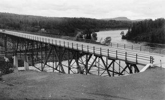
The Nipigon River Bridge, originally opened in 1937, forms a bottleneck in the Canadian transport network between the Atlantic and Pacific |
||
The Nipigon River is a 48 km long river in the Canadian province of Ontario .
The river drains the Lake Nipigon , flowing south and empties into the Nipigon Bay , a bay of Lake Superior . The height at its outflow from the Nipigonsee is 260 m . At its mouth there are still 183 m . At the end of May 2011 the average runoff at Alexander Dam was 420 m³ / s.
history
Archaeological traces show the continuous presence of humans from around 2000 BC. After. Between 3000 BC and 1000 AD, extensive trade routes were established. In summer these were canoe trails that were used with birch bark canoes, in winter trails that were suitable for sled dogs. Between 1717 and 1905, six trading bases were built, which were frequented by members of the six First Nations surrounding them. The indigenous peoples, in turn, became part of the money economy when they began to offer their guide services for a fee based on their knowledge of the area and nature. The Nipigon River was legendary for the amount and size of the brook trout found here . However, the construction of four dams (Cameron Falls Dam, Virgin Falls Dam (built 1925), Alexander Dam, Pine Portage Dam) along the course of the river resulted in a sharp decline in the fish population.
Use of hydropower
North of Lake Nipigon, part of the Ogoki River , a tributary of the Albany River , is diverted. Instead of flowing into James Bay as it was originally , 121 m³ / s now flow to Lake Nipigon, effectively enlarging the catchment area of the Nipigon River and increasing the mean discharge and the amount of water that can be used to generate electricity. The hydropower plants at Cameron Falls Dam, Alexander Dam and Pine Portage Dam together deliver an annual output of around 2.144 TWh (in 2002). All three hydropower plants are operated by the Ontario Power Generation . In the downstream direction these are:
| Surname | completion position |
Water level [m] |
Power [MW] |
Number of turbines |
|---|---|---|---|---|
| Pine Portage | 1950-1954 | 259.55 | 142 | 4th |
| Cameron Falls | 1918-1958 | 227.07 | 87 | 7th |
| Alexander | 1930-1958 | 203.25 | 69 | 5 |
Fishing
The Nipigon River is a popular destination for anglers. In 1915, Dr. Cook the largest brook char to date. Four years later, Prince Edward, Prince of Wales (later King Edward VIII and Duke of Windsor) went fishing on the Nipigon River. A char caught in the process is still on display in the National Archives of Canada . Arctic char , rainbow trout and salmon can also be found in the Nipigon River several times a year . The migrating fish meet the first dam 15 km above the estuary. The reservoirs above the dams are suitable for catching American char. The fishing season starts on May 1st and lasts until the end of November.
literature
- Nipigon River System. Water Management Plan , Ontario Power, 2005.
Web links
Individual evidence
- ↑ a b The Atlas of Canada - Lakes ( Memento from January 14, 2013 in the Internet Archive ) (English)
- ↑ The Atlas of Canada - Rivers ( Memento from January 22, 2013 in the Internet Archive ) (English)
- ^ Ontario Power Generation
- ^ Nipigon River System. Water Management Plan , Ontario Power, 2005, p. 46.
- ↑ Michael Stephen Noone: Interbasin Water Transfer Projects In North America (PDF) North Dakota State Water Commission. Pp. 4-5.10. March 13, 2006. Archived from the original on June 23, 2010. Retrieved June 14, 2010.
- ↑ Lake Nipigon Conservation Reserve Resource Management Plan (PDF; 413 kB) Accessed July 27, 2011.
- ↑ Ontario Power Generation (PDF file; 887 kB)
- ↑ Whalen, James; The Archivist : Royalty on the Nipigon; 1998; no.117

