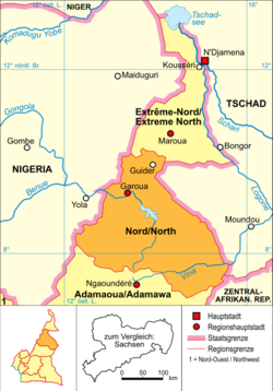
North (Cameroon)
|
Nord (French) North (Engl.) |
|
|---|---|
| Basic data | |
| Capital : | Garua |
| Area : | 65,576 km² |
| Residents : | 2,442,600 (calculation, 2015) |
| Population density : | 37.25 inhabitants / km² (calculation, 2015) |
| ISO 3166-2 : | CM-NO |
Nord ( French ) or North ( English ) is a region of Cameroon with the capital Garua .
geography
The region is located in the north of the country and is bordered by the Far North to the north , Chad to the east, the Central African Republic to the southeast, the Adamaua region to the south and Nigeria to the west . On the border with Chad is the 2200 km² Bouba-Ndjida National Park and on the border with Nigeria the 3300 km² Faro National Park .
The topography of the province is largely shaped by the Adamaua highlands , which are up to 2,710 meters high. In the northwest lie the foothills of the Mandara Mountains . The province is crossed by the largest tributary of the Niger , the Benue, with its numerous tributaries, such as the Mayo Kébbi . The south-east of the province lies in the Logone catchment area and is part of the Chad Basin .
Population development
Since 1976 the population has increased more than fivefold.
| year | population |
|---|---|
| 1976 census | 479.158 |
| 1987 census | 832.165 |
| 2005 census | 1,687,959 |
| 2015 estimate | 2,442,600 |
Political structure
The region is divided into 4 districts. In the table below, the district capital is assigned to the respective district.
|
history
The region (until 2008 province) was created in 1983 with the division of the province North / North into the provinces Adamaua , High North and today's region North / North.


