North Andover, Massachusetts
| North Andover | |
|---|---|
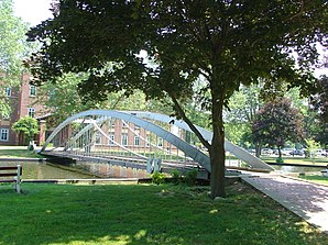
 Brooks School |
|
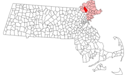
| North Andovers location | |
| Basic data | |
| Foundation : | 1644 (inc. 1855) |
| State : | United States |
| State : | Massachusetts |
| County : | Essex County |
| Coordinates : | 42 ° 42 ′ N , 71 ° 8 ′ W |
| Time zone : | Eastern ( UTC − 5 / −4 ) |
| Residents : | 28,352 (as of 2010) |
| Population density : | 416.3 inhabitants per km 2 |
| Area : | 71.9 km 2 (approx. 28 mi 2 ) of which 68.1 km 2 (approx. 26 mi 2 ) are land |
| Height : | 23 m |
| Postal code : | 01845 |
| Area code : | +1 978 |
| FIPS : | 25-46365 |
| GNIS ID : | 0618306 |
| Website : | www.townofnorthandover.com |
| Mayor : | Mark DiSalvo |
 |
|
North Andover is a small town ( Town ) in Essex County in Massachusetts , United States .
Division of the town
Around 1705, the population of Andover began to expand southwards, so the idea of building a new meeting house at the southern end of the city came up. This intention met with resistance from the residents of northern Andover. The dispute was settled in 1709 when the Great and General Court divided Andover into two parishs , a northern and a southern. Politically, however, Andover remained a unit.
For many years, Andover was the largest geographical town in the Commonwealth of Massachusetts. In 1826 a third parish was established and West Parish Church was established on Reservation Road. In 1854 it was decided to split the town into two politically independent units. The boundaries ran along the former parishes, with the name Andover being adopted by the more populous and affluent Parishs to the west and south, and the northern Parish being named North Andover.
traffic
North Andover is adjacent to Interstate 495 on the Salem – North Andover and Wilmington – Agamenticus lines of the Boston and Maine Railroad , as well as on the Bay Circuit Trail .
Culture
Among the places of great interest in North Andover include:
- The Harold Parker State Forest , an approximately 12 km² state-owned mixed forest that is accessed by a dense network of dirt roads and trails and offers numerous opportunities for active recreation.
- In the Museum of Printing the history of printing and the development of the technology of reproduction before the introduction of photocopiers are presented.
- The North Andover Historical Society , founded in 1913, focuses on the representation of everyday life in North Andover between 1700 and 1850, the exhibitions are in Parson Barnard House (1715) and Johnson Cottage (1789).
- Stevens-Coolidge Place , which emerged from Ashdale Farm, was the summer home of diplomat John Gardner Coolidge and his wife Helen Stevens Coolidge; In addition to the various gardens, the collections of Asian and European art and American furniture are also of interest.
- The Ward Reservation is dedicated to the preservation of New England's agricultural traditions by protecting around 40 parcels of former farm and pasture land and the historic stone walls that border them, some 27 kilometers in length.
- Weir Hill is a double drumlin on Lake Cochichewick; from its ridge, opened up by about 6 kilometers of hiking trails, there are beautiful views of Stevens Pond and the valley of the Merrimack River.
- At Brooks School , many of the notable people graduated from North Andovers.
- The Merrimack College ice hockey team plays in the Hockey East Association .
- The rock band Rev Theory hails from North Andover.
Personalities
- Cliff Bleszinski (* 1975), computer game developer
- Phillips Brooks (1835-1893), Bishop
- Jake Burton Carpenter (1954-2019), snowboarder
- Charlie Davies (born 1986), soccer player
- Daniel Dennett (* 1942), philosopher
- Robert Gagné (1916-2002), psychologist
- John LeBoutillier (born 1953), politician
- George B. Loring (1817-1891), politician
- William J. Miller (1899–1950), politician
- Gayton P. Osgood (1797–1861), politician
- Samuel Osgood (1748–1813), politician
- Lorenzo Semple junior (1923-2014), screenwriter
- Charles A. Stevens (1816-1892), politician
- Isaac Ingalls Stevens (1818-1862), General
- Moses T. Stevens (1825–1907), politician
Individual evidence
- ↑ Town of North Andover in the Geographic Names Information System of the United States Geological Survey , accessed May 18, 2014
- ^ Sarah Loring Bailey: Historical Sketches of Andover ( English ) 1880.
