Bay Circuit Trail
| Bay Circuit Trail & Greenway | |
|---|---|
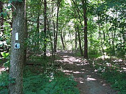
 Section of the hiking trail in Concord |
|
| Data | |
| length | 200 mi (321.9 km ) |
| location | Massachusetts , United States |
| Supervised by | Bay Circuit Alliance |
| Markers | |
| Starting point |
Plum Island , Newburyport 42 ° 48 ′ 57.3 " N , 70 ° 49 ′ 6.9" W. |
| Target point | Kingston Bay, Massachusetts 42 ° 0 '9.7 " N , 70 ° 43' 3.4" W. |
| Type | Long-distance hiking trail |
| Height difference | 163 m |
| The highest point | Moose Hill (approx. 163 m) |
| Level of difficulty | Easy |
The Bay Circuit Trail is a 200 mi (321.9 km ) long distance hiking trail located in the state of Massachusetts , United States . It begins north of Boston on Plum Island in Newburyport , leads in a wide arc counterclockwise through the eastern areas of the state around the Greater Boston metropolitan area and finally ends at Kingston Bay on the Atlantic again . The trail is managed by the Bay Circuit Alliance (BCA), founded in 1990 , which has been supported by the Appalachian Mountain Club and the Trustees of Reservations since 2012 .
Description of the trail
history
The first concept of the long-distance hiking trail was created in 1929 with the aim of creating an "outer emerald necklace " that conceptually takes up the famous Boston life work of Frederick Law Olmsted , but exceeds it many times over in terms of size. The Bay Circuit Trail was designed to provide the growing population in the Greater Boston metropolitan area with green spaces and other recreational opportunities. In the following years, isolated parks and protected areas were created between Massachusetts Route 128 and Interstate 495 , but their development could not keep pace with the rapid growth in population. It was only with the establishment of the Bay Circuit Alliance in 1990 that the potential was created to help the 60-year-old concept to a new beginning and to close the remaining gaps. Today it offers the metropolitan region with more than 4 million inhabitants a wide variety of recreational opportunities, including horse riding , hiking , cycling , snowshoeing and skiing .
Sections
The trail consists of a total of 16 individual sections and begins in Section 1A on Plum Island in Newburyport , from where it continues via Newbury to Rowley . The last section No. 14 (sections 1 and 5 have been divided into sections A and B) runs through the towns of Pembroke , Duxbury and Kingston and ends at Kingston Bay.
Bay Circuit Alliance
The association, which today consists of 40 member organizations, was founded in 1990 to turn the vision of the hiking trail into reality. This was done step by step and with extensive support from the 34 cities through which the Bay Circuit Trail runs. The BCA works closely with the municipalities, among other things, on planning, route regulations and any necessary construction work. In 2012, the Appalachian Mountain Club and the Trustees of Reservations joined the BCA in order to complete the hiking trail by closing existing gaps and maintaining it in the long term.
Individual evidence
- ↑ a b About BCA. (No longer available online.) Bay Circuit Alliance, archived from the original on December 3, 2013 ; accessed on September 29, 2013 (English). Info: The archive link was inserted automatically and has not yet been checked. Please check the original and archive link according to the instructions and then remove this notice.
- ↑ Explore. (No longer available online.) Bay Circuit Alliance, formerly the original ; accessed on September 29, 2013 (English). ( Page no longer available , search in web archives ) Info: The link was automatically marked as defective. Please check the link according to the instructions and then remove this notice.
Web links
- Official website
- Map of the Bay Circuit Trail. ( PDF ; 1.9 MB) Bay Circuit Alliance, accessed on September 29, 2013 .
