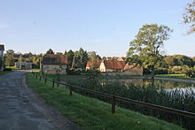
Nová Ves (Lukov)
| Nová Ves | ||||
|---|---|---|---|---|
|
||||
| Basic data | ||||
| State : |
|
|||
| Region : | Jihomoravský kraj | |||
| District : | Znojmo | |||
| Municipality : | Lukov | |||
| Geographic location : | 48 ° 51 ' N , 15 ° 54' E | |||
| Height: | 406 m nm | |||
| Residents : | ||||
| Postal code : | 669 02 | |||
| License plate : | B. | |||
| traffic | ||||
| Street: | Lukov - Nová Ves | |||
Nová Ves (German Neudorf ) is a settlement of the minority Lukov in the Czech Republic . It is located ten kilometers west of Znojmo near the Czech-Austrian border and belongs to the Okres Znojmo .
geography
Nová Ves is located on the edge of the Podyjí National Park in the Vranovská pahorkatina ( Fraina hill country ). The settlement lies on the left side above the source of the Lukovský creek. To the east rises the Kozí vrch (430 m nm), in the southeast the Horka (431 m nm), the Čerchov (438 m nm) and the Lipina (438 m nm), to the southwest the Ostroh ( Stollfürst , 357 m nm), the Umlaufberg (378 m above sea level) and the Gališ ( Brendenberg , 404 m nm) as well as the Lukovská horka ( Horka , 421 m nm) in the northwest . The Žlebský potok ( Schlebbach ) rises south-east of Nová Ves . The meandering Kerbtal of the Thaya , which forms the border with Austria on this section, runs one and a half to two kilometers to the west and south of the village .
Neighboring towns are Lukov in the north, Bezkov in the north-east, Mašovice in the east, Podmolí in the south-east, Niederfladnitz in the south, Merkersdorf in the south-west, Hardegg in the west and Čížov in the north-west.
history
On the site of Nová Ves there used to be a manorial farm, which has also had a brewery since 1600.
Neudorf was created in 1798 by the owner of the Allodialherrschaft Frain including the castle Neuhäusel , Joseph Hilgartner Ritter von Lilienborn, on the hill opposite Luggau in the corridors of the emphyteutically sold Meierhof. In the following year Hilgartner sold the rule to Stanislaw Count Mniszek.
In 1834 the village of Neudorf or Nowa Wes consisted of 20 houses with 104 predominantly German-speaking residents. The parish and school location was Luggau. Until the middle of the 19th century, Neudorf remained subject to the Frain and Neuhäusel rulers. The place of office was the Markt Frain .
After the abolition of patrimonial formed Neudorf / Nová Ves in 1849 a district of the market Luggau in the judicial district Frain. In 1868 the village became part of the Znojmo region. .
After the First World War , the multi-ethnic state Austria-Hungary disintegrated , and in 1918 Neudorf became part of the newly formed Czechoslovak Republic . In the mid-1930s, two light bunker lines of the Czechoslovak Wall were built between Neudorf and Baumöhl and along the border in the Thayatal . After the Munich Agreement , the village was occupied by German troops in 1938 and assigned to the German district of Znojmo . In 1939 the place consisted of 32 houses. After the end of the Second World War, Nová Ves returned to Czechoslovakia and became part of the Okres Znojmo again . The German residents of Nová Ves were expelled in 1945 and 1946 .
The border to Austria was closed in 1945. After 1948, the “ Iron Curtain ” was built well before the border . In the restricted area that were ruined castle Novy Hradek and the mills Faltýskův Mlýn ( Devil's Mill , also circulating mill ) and Novohrádecký Mlyn ( Neuhäuselmühle ) in the Thayatal. In 1960 Nová Ves lost its status as a district of Lukov.
After the Velvet Revolution in 1989, the Iron Curtain began to open. The former restricted area was declared the Podyjí National Park in 1991 .
Attractions
- Castle ruins Nový Hrádek ( Neuhäusel ), south of the village above the Thaya valley
- Deeply incised Thaya valley with river bends on Umlaufberg and Stollfürst, the Vraní skála rock cliffs and the weirs and ruins of the Faltýskův Mlýn and Novohrádecký Mlýn mills
- Folk style homesteads
Web links
- Description of the location of Luggau and Neudorf on suedmaehren.at
- Description of the location of Luggau and Neudorf on europas-mitte.de
Individual evidence
- ^ Gregor Wolny : The Margraviate Moravia topographically, statistically and historically described , III. Volume: Znaimer Kreis (1837), pp. 205–206


