Nukuoro
| Nukuoro | ||
|---|---|---|
| ISS image by Nukuoro | ||
| Waters | Pacific Ocean | |
| archipelago | Carolines | |
| Geographical location | 3 ° 51 ′ N , 154 ° 56 ′ E | |
|
|
||
| Number of islands | 44 | |
| Main island | Nukuoro Islet | |
| length | 8 kilometers | |
| Land area | 1.67 km² | |
| Lagoon area | 27.25 km² | |
| total area | 40 km² | |
| Residents | 372 (2007) | |
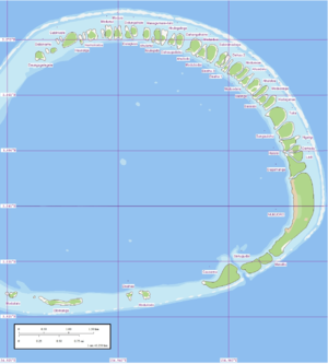
| Map of Nukuoro | ||
Nukuoro , formerly Monteverde , is an atoll in the Federated States of Micronesia . It is part of the state of Pohnpei .
geography
Nukuoro has a population of less than 400 people.
The lagoon has a diameter of 6 km. The total area of the atoll is 40 km², but the land area is only 1.67 km². Of this, 0.466 km² or 46.6 hectares are on the main island of Nukuoro, which is six times the size of the second largest island, Gausema . The islands' resources are therefore limited. The residents live from fishing, a little agriculture and the rearing of farm animals.
The atoll is comparatively remote. There is no runway and little shipping traffic: a passenger ship calls at the island once a month. The atoll is also visited by cruise ships from time to time .
language
They speak a language from the Polynesian language group called "Nukuoro". The island is therefore one of the Polynesian exclaves , which are outside the Polynesian triangle .
Islands
The islands of the atoll are listed in clockwise order, starting in the north or northwest:
| No. | Motu | Area ( ha ) |
Population 2007 |
|---|---|---|---|
| 1 | Deungagel gels | ... | ... |
| 2 | Dalainamu | ... | ... |
| 3 | Gabinivele | ... | ... |
| 4th | Hauosiga | 0.3 | ... |
| 5 | Namoilodoa | ... | ... |
| 6th | Modunui | ... | ... |
| 7th | Moduia | ... | ... |
| 8th | Dalagivao | ... | ... |
| 9 | Dolungahale | ... | ... |
| 10 | Ahulanui | 0.1 | ... |
| 11 | Niulegida | ... | ... |
| 12 | Masagumani-ilalo | ... | ... |
| 13 | Ahulegalega | ... | ... |
| 14th | Dahaugadabu | ... | ... |
| 15th | Dahangahaino | ... | ... |
| 16 | Ahuilodo | ... | ... |
| 17th | Moduidua | ... | ... |
| 18th | Modubodai | ... | ... |
| 19th | Sabinimadogo | ... | ... |
| 20th | Deahu (northern) | ... | ... |
| 21st | Deahu (middle) | ... | ... |
| 22nd | Deahu (southern) | ... | ... |
| 23 | Moduovae | ... | ... |
| 24 | Ahuedolu | ... | ... |
| 25th | Moduodula | ... | ... |
| 26th | Ahuloloa | ... | ... |
| 27 | Baonga | ... | ... |
| 28 | Moduovega | ... | ... |
| 29 | Balaiasi | ... | ... |
| 30th | Haduganae | ... | ... |
| 31 | Tuila | ... | ... |
| 32 | Sungaulohu | ... | ... |
| 33 | Ngaligi | ... | ... |
| 34 | Haisisi | ... | ... |
| 35 | Demodule | ... | ... |
| 36 | Ladi | ... | ... |
| 37 | Dagamanga | ... | ... |
| 38 | Nukuoro | 46.6 | ... |
| 38a | Masakomani 1) | ... | ... |
| 39 | Masagumani-ingage | ... | ... |
| 40 | Masabu | ... | ... |
| 41 | Senugudai | ... | ... |
| 42 | Gausema | 7.8 | ... |
| 43 | Moduilodo | ... | ... |
| 44 | Deahua | ... | ... |
| 45 | Olomanga | ... | ... |
| 46 | Moduilalo | ... | ... |
| Nukuoro | 167 | 372 |
1) Masakomani, formerly a separate island, now forms the southernmost part of the main island of Nukuoro.
literature
Pacific Languages: An Introduction John Lynch, University of Hawaii Press, 1998 pp. 50–51 "polynesian outliers"
Individual evidence
- ^ Edwin Horace Bryan: Guide to place names in the Trust Territory of the Pacific Islands: (the Marshall, Caroline and Mariana Islands) (Paperback). Honolulu: Pacific Scientific Information Center, 1971 (Original data: 0.180 sq. Mi. Or 0.030 sq.mi.).
- ↑ Vern Carroll: Place names on Nukuoro Atoll, Atoll Research Bulletin No. 107, September 30, 1954 (PDF; 580 kB)
Web links
- Images from NASA Earth Observatory
- Detailed maps of the atoll and its motus
- Nukuoro on Oceandots ( Memento from December 23, 2010 in the Internet Archive )


