
Nyíradony
| Nyíradony | |||||
|
|||||
| Basic data | |||||
|---|---|---|---|---|---|
| State : | Hungary | ||||
| Region : | Northern Great Plain | ||||
| County : | Hajdú-Bihar | ||||
| Small area until December 31, 2012 : | Hajdúhadház | ||||
| Coordinates : | 47 ° 41 ′ N , 21 ° 54 ′ E | ||||
| Height : | 90 m | ||||
| Area : | 96.59 km² | ||||
| Residents : | 7,836 (Jan 1, 2011) | ||||
| Population density : | 81 inhabitants per km² | ||||
| Telephone code : | (+36) 52 | ||||
| Postal code : | 4254 | ||||
| KSH kódja: | 06187 | ||||
| Structure and administration (as of 2015) | |||||
| Community type : | city | ||||
| Mayoress : | Mária Kondásné Erdei (Fidesz-KDNP) | ||||
| Postal address : | Árpád tér 1 4254 Nyíradony |
||||
| Website : | |||||
| (Source: A Magyar Köztársaság helységnévkönyve 2011. január 1st at Központi statisztikai hivatal ) | |||||


Nyíradony [ ˈɲiːrɒdoɲ ] is a city in eastern Hungary in Hajdú-Bihar County with 7,836 inhabitants (as of 2011). Nyíradony is located 26 kilometers northeast of Debrecen . The urban area covers an area of 9,570 hectares.
Worth seeing
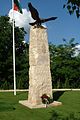
Turul Monument in Nyíradony

Hunting lodge near Nyíradony
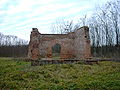
Ruin of a small chapel


- Large sports hall with indoor pool and sauna
- Greek Catholic church with beautiful wall painting in the center of the village
- Ruins of a small chapel that was destroyed by the Tatars in the 12th century
Town twinning
Transport links
- By car: Nyíradony is right on the 471 road that leads to Debrecen.
- By train: There are a few trains that go directly to Budapest , for long-distance connections you generally have to change trains in Debrecen.
Web links
Commons : Nyíradony - collection of images, videos and audio files