Oelber on the white path
|
Oelber on the white path
Oelber municipality Baddeckenstedt
Coordinates: 52 ° 6 ′ 4 ″ N , 10 ° 14 ′ 5 ″ E
|
|
|---|---|
| Height : | 120 m above sea level NN |
| Residents : | 1465 (2002) |
| Incorporation : | March 1, 1974 |
| Postal code : | 38271 |
|
Location of Oelber on the white road in the municipality of Baddeckestedt
|
|
|
Oelber Castle in Oelber on the white road
|
|
Oelber am white ways is a district of the municipality Baddeckestedt in the district Wolfenbüttel with 1465 inhabitants (2002). Earlier chroniclers described Oelber aw ways (also: awW) as a “picturesque little village between wooded ridges”. The place is known for the picturesque Oelber Castle of the Barons von Cramm .
geography
The village can be reached from the B 6 and from Salzgitter-Lichtenberg via a district road. It is located in a remote valley south of the Lichtenberge as the northwestern part of the Salzgitter ridge .
history

The current spelling of Oelber has changed in the last few centuries from "Olbere" to "Ölper" and "Ölber". The origin of the name is not clearly clarified and its interpretation is also controversial. The first syllable could mean alabure / alah for sanctuary . The second syllable is possibly derived from -bur ( Westphalian : -büren), which means settlement. Another opinion sees the ending “-ber” or “-per” meaning “settlement on the heights”. Loosely translated, the name Oelber could then mean “sanctuary on the heights” or “holy settlement”. The origin of the place name is assumed to be in the 5th to 8th centuries.
The addition of “on the white road”, which only appeared in the 16th century, expresses the fact that the village was close to a lime works. The white path was a connection path to Groß Elbe , which showed traces of white lime due to the removal of lime. The “White Way” can still be found today as a street name in Groß Elbe. The additional designation served to rule out any confusion with the village of Ölper near Braunschweig , which also belonged to the Duchy of Braunschweig .
The first written mention of the village of Oelber on the white road was in 1226 in the fiefdom register of the noble lords of Meinersen. The noble family built today's Oelber Castle as a medieval moated castle in the 12th century . The local history is inextricably linked with the noble von Cramm family. In 1296 they were first mentioned as co-owners of Oelber Castle and currently a branch of the family is located in today's castle. The bishops of Hildesheim had territorial rule over the place since 1353, for the first time through Bishop Heinrich von Hildesheim. This lasted until the end of the Hildesheim collegiate feud in 1523. In 1543 Oelber came to the Duchy of Braunschweig. It was located in the extreme southwest corner of the Brunswick area and was surrounded by foreign territories. In 1597 the village survived a plague epidemic.
During the Thirty Years' War in 1626, the imperial general, Count Tilly, quartered with his troops in Oelber Castle for three months . After his departure, the Danish army under Count Philipp Reinhard von Solms took the castle and devastated it as well as the village. Tilly's troops placed the Danes under King Christian IV on the white road about 15 km south of Oelber and defeated them on August 27, 1626 in the battle of Lutter am Barenberge. In 1771 the villagers rebuilt the village after the destruction of the Seven Years' War (1756–1763). In addition to the church and castle, it then had 62 houses. 20 years later, 602 residents were counted.
Between the Peace of Tilsit in 1807 and the Battle of the Nations near Leipzig in 1813, the Electorate of Braunschweig-Lüneburg belonged to the Kingdom of Westphalia . The place belonged to the canton Gebhardshagen at this time .
On June 7, 1961, Oelber was hit by a 1.5 m high tidal wave on the white road, which claimed two lives. This was preceded by heavy downpours, the water of which shot down the valley in which the village was located. In 1963 the community celebrated its 800th anniversary. At that time, the von Crammsche Rittergut had 1500 acres of land and 42 workers. In 1960 there were exterior shots of Oelber Castle for the movie Das Spukschloß im Spessart .
The Oelber settlement has always been characterized by agriculture. The manor of the von Cramm family with extensive livestock and ancillary businesses, such as a distillery, brickworks, lime works and brewery , gave the villagers wages and bread. The population was between 300 and 400 people in the last centuries. After the Second World War, it skyrocketed and since then has quadrupled to around 1,800 inhabitants by 2012.
In 1974 the place lost its status as an independent municipality due to the regional and municipal reform and became a part of Baddeckestedt. The village community center was built in 1986 on the initiative of several associations.
religion
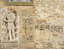
The local church is St. Anne's Church near Oelber Castle, a church built by Burchard and Franz von Cramm in 1594. Inside and on the outside walls, numerous epitaphs of the previous lords of the castle, the von Cramm family and their relatives, are attached. Since then, the church has been a patronage church , for the maintenance of which the noble family was responsible.
literature
- Community of Oelber aw W. (Ed.): 800 years of Oelber aw ways . Festschrift for the anniversary celebrations in June 1963, Braunschweig 1963


