
Oelzetal Bridge
Coordinates: 50 ° 33 ′ 27 ″ N , 10 ° 59 ′ 40 ″ E
| Oelzetal Bridge | ||
|---|---|---|
 |
||
| Convicted |
High- speed line from Nuremberg to Erfurt |
|
| Subjugated | Oils | |
| place | Altenfeld | |
| construction | Arch bridge | |
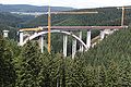
| overall length | 370 m | |
| width | 14.1 m | |
| Longest span | 165 m | |
| Construction height | 3.6 m | |
| height | 71 m | |
| start of building | 2007 | |
| completion | 2011 | |
| location | ||
|
||

The Oelzetalbrücke is a 370 m long double-track railway overpass structure on the new Ebensfeld – Erfurt line , which is located between the Fleckberg tunnel and the Silberberg tunnel . The bridge stands in southern Thuringia east of Altenfeld between the route kilometers 139.556 and 139.926 and spans the Oelzetal with the Oelze brook with an arch of 165 m span . The route lies at a maximum height of 71 m above the valley floor and is straight in the structural area at a design speed of 300 km / h. The bridge has a slab track with a distance of 4.5 m between the tracks and a noise protection wall on the western side .
history
The building was put out to tender in spring 2007 and awarded to a consortium with a construction volume of 11 million euros net in autumn 2007. With the demolition of the supporting pillars necessary for the construction in September 2010, the construction work was essentially completed. The completion of the building was planned for the end of 2010. The work on the edge caps and the slab of the slab track was completed in October 2011.
Substructure

The pillar of the bridge have a rectangular reinforced concrete hollow cross-section with broken corners and tapered with a suit of 70: 1 upwards. The six stands on the arch do not have a suit, their dimensions are constant. The reinforced concrete arch with a span of 165 m and a pitch of 40.7 m also has a hollow cross-section and is accessible. The arch was built in cantilever with auxiliary pillars. The northern abutment is the fixed point of the bridge and in particular transfers the longitudinal forces from braking into the subsoil. At the expansion joint of the southern abutment there is a rail extension with a compensating plate.
About 8500 m³ of concrete were installed to create the foundation, the arch, the pillars and the abutment.
The closing of the arch was celebrated on May 19, 2010. After the arch was self-supporting, the six double auxiliary pillars, 25 to 65 m high and consisting of 1,800 m³ of concrete and 250 t of reinforcing steel, followed on September 25, 2010.
superstructure

The superstructure has a continuous beam with 13 fields as a building system . To the south of the arch there are three openings with 30 m, 35 m and 40 m span, above the arch for the elevated deck girder seven openings with 23.57 m each and to the north of the arch three fields with 40 m, 30 m and 30 m span . The superstructure has the cross-sectional shape of a single-cell reinforced concrete hollow box with inclined webs, prestressed in the longitudinal direction . In addition, the deck is prestressed in the transverse direction. The maximum width of the superstructure is 14.1 m. The construction height is 3.6 m. The superstructure was built using the incremental launching method . In September 2010, the last section of the superstructure was concreted. Around 4700 m³ of concrete were required to produce the superstructure and the edge caps.
There was a requirement of around 1300 tons for reinforcing steel and prestressing steel for the substructure and superstructure.
gallery

April 2009

December 2009

April 2010
August 2010

Support plate in August 2011, view of the Silberberg tunnel

October 2016, slab track with rail extension


literature
- W. Heine, H.-J. Jonas, M. Kästner, E. Lederhofer, R. Wiest: ICE route Nuremberg – Erfurt. Arch bridges over the valleys of the Thuringian Forest . In: civil engineer . No. 3/2015 . Springer-VDI-Verlag, March 2015, ISSN 0005-6650 , p. 104-114 .
Web links
- Brochure on vde8.de (PDF file; 120 kB)
- Pictures of the construction site on bastellen-doku.info
Individual evidence
- ↑ Schüßler plan: Route brochure for the new VDE 8.1 line from Breitengüßbach to Erfurt. Published by DB Netz AG Regional Area Southeast. As of June 1st, 2017. p. 112 ( page no longer available , search in web archives ) Info: The link was automatically marked as defective. Please check the link according to the instructions and then remove this notice.
- ↑ a b www.kirchner.de: Bridge building projects ( page no longer available , search in web archives ) Info: The link was automatically marked as defective. Please check the link according to the instructions and then remove this notice.
- ↑ Picture by picture: The pillars of the Oelzetal bridge blown up . At: www.thueringer-allgemeine.de, September 26, 2010, accessed on January 5, 2011.
- ↑ a b c DB ProjektBau GmbH regional area south-east: project description, status November 2009 (PDF file; 926 kB)
- ↑ Deutsche Bahn AG (Ed.): 165 meters of bridge arch built over the Oelze . Press release from May 19, 2010
- ↑ DB ProjektBau GmbH: The arch of the Oelzetalbrücke is now freely above the valley floor ( page no longer available , search in web archives ) Info: The link was automatically marked as defective. Please check the link according to the instructions and then remove this notice. . Press release from September 25, 2010
- ↑ Submissionsanzeiger from March 19, 2007 ( Memento from January 16, 2009 in the Internet Archive )