
Furnace (mountain)
| oven | ||
|---|---|---|
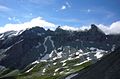
 Furnace from the east, i.e. the Grisons side; Tschingelhörner on the right and Grischsattel on the far left. |
||
| height | 2873 m above sea level M. | |
| location | Border canton Glarus / Canton Graubünden , Switzerland | |
| Mountains | Glarus Alps | |
| Dominance | 1.15 km → Laaxer Stöckli | |
| Notch height | 113 m ↓ Grischsattel | |
| Coordinates | 735 288 / 194 616 | |
|
||
| rock | Verrucano structure on limestone | |
| Age of the rock | Verrucano | |
 From the west: furnace on the right edge of the picture as the third horizon; above Piz Dolf, middle of the Atlas. To the left of the stove Tschingelhörner with Martinsloch , behind (highest point) Piz Segnas |
||

The furnace , 2873 m, is a summit in Switzerland on the border of the cantons of Glarus and Graubünden . The summit structure - like that of the neighboring Tschingelhörner - consists of the very old rocks of the Verrucano ceiling, which were pushed over the much younger flysch layers that form the steeper base of the mountain when the Alps unfolded . The thrust line is now a UNESCO World Heritage Site and is clearly visible on the furnace because the brittle Verrucano rock is flatter than the stronger and therefore steeper flysch.
A few decades ago the little steep south-eastern summit surface remained covered with snow for a very long time, since the 1990s one had to get used to a new sight with an empty summit in summer . The summit is located south of the Segnespass , which connects Elm in the canton of Glarus with Flims in the canton of Graubünden , separated from it by the Tschingelhörner .
Access
The mountain is easy to climb from the south, either from Elm or from Flims. Glarus side: From the Martinsmadhütte SAC a path leads to the Ofenrus and the Grischsattel 2760 meters, from there to the north. From the Grisons side also to the Grischsattel. In the summer of 2009, a trial bus from Laax to Nagens at 2127 meters above sea level was in operation. The summit is also climbed in winter.
Individual evidence
- ↑ National map 1: 25,000 Elm, number 1174.
The stove and Tschingelhörner with Martin's hole
