
Olszanka (Podegrodzie)
| Olszanka | |||
|---|---|---|---|
 Help on coat of arms |
|
||
| Basic data | |||
| State : | Poland | ||
| Voivodeship : | Lesser Poland | ||
| Powiat : | Nowy Sącz | ||
| Gmina : | Podegrodzie | ||
| Area : | 3.22 km² | ||
| Geographic location : | 49 ° 33 ' N , 20 ° 33' E | ||
| Height : | 320-430 m npm | ||
| Residents : | 630 (2010) | ||
| Postal code : | 33-386 | ||
| Telephone code : | (+48) 18 | ||
| License plate : | KNS | ||

Olszanka (formerly Mała Olszanka , German Ollschau ) is a village with a Schulzenamt of the municipality Podegrodzie in the powiat Nowosądecki of the Lesser Poland Voivodeship , Poland .
geography
The place is by the river Jastrzębik in Inselbeskiden ( Beskid Wyspowy ).
The village has an area of 322 hectares (5% of the rural parish).
The neighboring towns are Naszacowice in the northeast, Kadcza in the south, Jazowsko in the southwest, Szczereż in the west, Olszana in the northwest.

The village in the parish

history
The place was first mentioned in a document between 1470 and 1480 years as Olschanka . The name is derived from the alder ( Polish olsza ). The place originally belonged to the Poor Clares in Stary Sącz.
After the First Partition of Poland , Olszanka became part of the new Kingdom of Galicia and Lodomeria of the Habsburg Empire (from 1804).
In 1784, in the course of the Josephine colonization, some German families of the Reformed denomination were settled as colonists. They belonged to the parish in Stadła . By the end of the 19th century, the colonists' descendants were Polonized. In 1900 the village had 417 inhabitants, all of them Polish-speaking, 338 Roman Catholic, 6 Jews, 73 other faiths (mostly Protestant).
In 1918, after the end of the First World War and the collapse of the Austro-Hungarian monarchy, Olszanka came to Poland. This was interrupted by the occupation of Poland by the Wehrmacht in World War II , during which it belonged to the Generalgouvernement .
From 1975 to 1998 Olszanka was part of the Nowy Sącz Voivodeship .

Town center
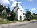
chapel
_-_centrum_wsi.jpg)
_-_kaplica_%C5%9Bw._Jana.jpg)
Web links
Individual evidence
- ↑ Henryk Lepucki: Działalność kolonizacyjna Marii Teresy i Józefa II w Galicji 1772-1790: z 9 tablicami i MAPA . Kasa im. J. Mianowskiego, Lwów 1938, p. 163-165 (Polish, online ).
- ↑ Ludwig Patryn (Ed.): Community encyclopedia of the kingdoms and countries represented in the Reichsrat, edited on the basis of the results of the census of December 31, 1900, XII. Galicia . Vienna 1907.

Brzezna | Chochorowice | Długołęka-Świerkla (Langendorf-Tannendorf) | Gostwica | Juraszowa (Jörgenau) | Mokra Wieś (Nassendorf) | Naszacowice (Naschatowitz) | Olszana | Olszanka (Ollschau) | Podegrodzie (Zaundorf) | Podrzecze (Unterbach) | Rogi | Stadła (Stadlau)