Battle for the Admiralty Islands
| date | February 29, 1944 to May 18, 1944 |
|---|---|
| place | Admiralty Islands |
| output | Allied victory |
| Parties to the conflict | |
|---|---|
| Commander | |
| Troop strength | |
| approx. 35,000 | approx. 4,000 |
| losses | |
|
326 dead, 1,189 injured, 4 missing |
3,280 dead |
1942
Rabaul -
1. Salamaua-Lae -
Operation MO -
Coral Sea -
1. Buna-Gona -
Kokoda Track -
Milne Bay -
Goodenough -
2. Buna-Gona -
Operation Lilliput
1943
Wau -
Bismarck Sea -
I -
2. Salamaua – Lae -
Finisterre -
Cartwheel -
Bougainville -
Huon -
Dexterity / Arawe -
Bombing of Rabaul
1944 - 1945
Admiralty Islands -
Emirau -
Take Ichi convoy -
Reckless -
Persecution -
Wakde-Sarmi -
Biak -
Noemfoor -
Driniumor -
Sansapor -
Morotai -
Aitape – Wewak
The battle for the Admiralty Islands was a complex landing operations of the Allied forces under the code name Operation Brewer on from Japanese -occupied units Admiralty Islands during the Pacific War in World War II . It was divided into several actions, the most important of which took place on the islands of Los Negros and Manus .
prehistory
On April 8, 1942, a Japanese light cruiser , a destroyer and a troop transport ran into the port of Lorengau . Japanese units of the 51st Division occupied the city within a very short time without encountering any resistance. The Australians, who had been stationed at Manus since November 1941, had withdrawn into the nearby jungle with little equipment and food. They fought their way to the south of the island, from where they managed to escape to Bogadjim ( Stephansort ) in Astrolabe Bay , south of Madang .
The Japanese built a 1220 m long runway near Momote on Los Negros , east of the sea eagle harbor . In 1943 another runway with a length of 1005 m was completed near Lorengau. In total, there were around 4,600 Japanese soldiers on the Admiralty Islands.
As part of the cartwheel plan drawn up by the SWPA to capture Japanese bases in the Papua and New Guinea territories , the conquest of the Admiralty Islands was planned to protect the eastern flank of New Guinea from approaches by Japanese fighter planes from Rabaul in order to be able to intercept them early.
By February 1944, the Allies had made tremendous progress. In New Guinea, McArthur's troops reached Lae and Salamaua in September 1943 , as well as Finschhafen a month later. The bases set up there allowed a far-reaching supremacy on water and in the air over the southern part of the Bismarck Sea , so that in December units could land on New Britain near Arawe and Cape Gloucester (→ Operation Dexterity ). In January 1944, Saidor was captured on the coast of New Guinea.
Admiral Halsey's fleet was meanwhile only around 230 km east of Rabaul. In mid-February 1944, during the attack on the Japanese Truk base (→ Operation Hailstone ), over 200 enemy combat aircraft and more than 20 ships were destroyed.
planning
In order to fully launch an attack in the west, MacArthur needed an additional base close enough for deployment purposes and with a port of sufficient size to accommodate a large amphibious assault. At the same time he wanted to ensure the protection of his right flank and prevent Japanese reinforcements from the area of the Bismarck Archipelago and the Solomon Islands from reaching the area. The Admiralty Islands with their natural harbors and airfields met these requirements to support later operations along the coast of New Guinea and against the Carolines and Marianas in the north. In addition, its strategic location offers an ideal base for the encirclement of the Japanese who have been cut off from New Britain and the Solomon Islands. The occupation of the Admiralty Islands by the Allies would finally seal the isolation of Rabaul .
The original plan envisaged an amphibious operation by the Southwest Pacific Forces against the islands on April 1 in connection with an attack by Admiral Nimitz's naval units on Kavieng . In February, however, the Allied reconnaissance revealed a considerable weakness in the Japanese defense against air and sea attacks. The main enemy positions were on the islands of Los Negros and Manus, the resistance of which would likely be low and easy to overcome.
Repeated aerial observation flights over Manus and Los Negros in late February reported a complete lack of enemy activity. It was observed that the Momote airfield was unused. The surrounding buildings and installations were apparently unattended and in poor condition. The persistent lack of anti-aircraft defenses reported by aerial reconnaissance supported the conclusion that the Japanese had completely abandoned the islands.
In contrast, MacArthur's G-2 Section estimated the total strength of the Japanese at around 3,250 on February 15 and increased their number to around 4,000 after a revision on February 24th. It led the lack of anti-aircraft fire to the deteriorated state of the logistical situation of the Enemy back.
As a result, the new plan included a reconnaissance force that should land in the port of Hyane in the east of Los Negros and, with little resistance, occupy the runway of Momote near the port entrance. In the event of strong resistance, an intervention force was deployed in Finschhafen for relief.
course
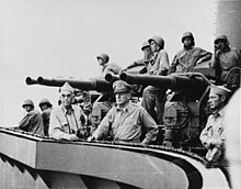
On the morning of February 29, the landing operation began with a reconnaissance force consisting of around 1000 soldiers from the 1st Cavalry Division , supported by two cruisers , a dozen destroyers and the necessary air security. The troop units consisted mainly of a reinforced squadron of the 5th Cavalry under Brigadier General William C. Chase ; The naval forces were under the command of Admiral Kinkaid , on whose flagship Phoenix was also General MacArthur.

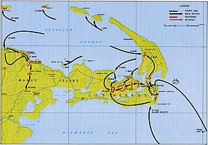
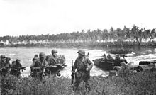
The first landing took place after a preliminary air and sea bombardment on the southwest bank of Hyane Harbor. The first waves of attack met with little resistance. Before the Japanese could recover from their surprise and position their heavy cannons facing the port of Seeadler , most of the troops were ashore. Under heavy rain, they fought sporadic and weak enemy fire and began preparing defensive positions along the runway.
After two days of hard fighting, in which determined Japanese attempts at infiltration and counterattacks were repulsed, the auxiliary troops of General MacArthur, who had arrived from Finschhafen, joined them on March 2nd. A hostile document captured the next morning revealed that a Japanese attempt would be made on the night of March 3 to retake Momote airfield. Quick preparations were made for the impending assault, which was likely to include most of the Japanese remaining west of Los Negros and any troops that could be brought across from nearby Manus Island.
The planned attack came as announced. In several waves the Japanese tried to push back the Allied units. The fighting lasted all night. The cavalrymen then waited for more troops to arrive before evacuating the rest of the islands. More reinforcements arrived on March 4th, 6th and 9th. The Allies stormed further west to take Papitalai and north to occupy the salami plantation. From the latter point they moved on across the port of Seeadler to conquer the Papitalai mission and the Lombrum plantation. By March 30, all organized enemy resistance against Los Negros had collapsed.
In the meantime operations began against the larger island of Manus. On March 15, after units of the 7th Cavalry had secured the two small islands of C and Butjo Luo off the north coast of Manus, attack troops from the 2nd Brigade landed in the Lugos mission, two miles west of Lorengau . The Lorengau airfield was captured on March 17th and the Allied units moved to Rossum on March 25th . This ended the campaign on the Admiralty Islands.
consequences
With the occupation of the Admiralty Islands, more than 100,000 Japanese were trapped in the Bismarck-New Britain-Solomon Islands area. In addition, the supply route to the Japanese external defense was shifted further west and the entire marine region between Truk and New Guinea was brought into the air range of the Allies. With the threat to his right flank removed, General MacArthur could concentrate all his attention on the task of moving further west along the New Guinea coast.
Individual evidence
- ↑ a b THE ADMIRALTIES Operations of the 1st Cavalry Division, CENTER OF MILITARY HISTORY, UNITED STATES ARMY, WASHINGTON, DC, 1990, at: https://history.army.mil/books/wwii/admiralties/admiralties-conclusion.htm ; accessed June 04, 2020
- ^ The Pacific War Online Encyclopedia, THE ADMIRALTIES, at: http://pwencycl.kgbudge.com/A/d/Admiralty_Islands.htm ; accessed June 4, 2020
- ↑ THE ADMIRALTIES Operations of the 1st Cavalry Division, CENTER OF MILITARY HISTORY, UNITED STATES ARMY, WASHINGTON, DC, 1990, at: http://www.history.army.mil/books/wwii/admiralties/admiralties-ch1-plan .htm ; accessed June 3, 2020
- ↑ HyperWar: Campaigns of MacArthur / I (Chapter 6) page 136. Retrieved on June 4, 2020 (English).
- ↑ HyperWar: Campaigns of MacArthur / I (Chapter 6) page 137. Retrieved on June 4, 2020 (English).
- ↑ HyperWar: Campaigns of MacArthur / I (Chapter 6) page 139. Retrieved June 4, 2020 (English).
- ↑ HyperWar: Campaigns of MacArthur / I (Chapter 6) pp. 140/141. Retrieved June 4, 2020 .
Web links
- http://www.history.army.mil/books/wwii/admiralties/admiralties-fm.htm
- https://www.history.navy.mil/browse-by-topic/wars-conflicts-and-operations/world-war-ii/1944/admiralty-islands.html
- http://www.historyofwar.org/articles/campaign_admiralty_islands.html
- Edward G. Miller, "World War II Action in the Admiralties Islands" on Warfare History Network


