Orurillo district
| Orurillo district | |
|---|---|
 The Orurillo District is located in the southeast of the Melgar Province |
|
| Basic data | |
| Country | Peru |
| region | Puno |
| province | Melgar |
| Seat | Orurillo |
| surface | 397 km² |
| Residents | 8041 (2017) |
| density | 20 inhabitants per km² |
| ISO 3166-2 | PE-PUN |
| Website | www.muniorurillo.gob.pe (Spanish) |
| politics | |
| Alcalde District | Alain Yorkman Mendizábal Gutiérrez (2019-2022) |
| Political party | Moral y Desarrollo |
| Orurillo | |
Coordinates: 14 ° 44 ′ S , 70 ° 31 ′ W
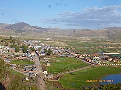
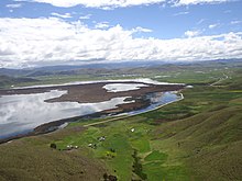
The Orurillo District is located in the Melgar Province in the Puno region in southeastern Peru . The district has an area of 397 km². The 2017 census counted 8,041 inhabitants. In 1993 the population was 9,897, in 2007 10,457. In 2017 , the main town and administrative seat of Orurillo , at an altitude of 3890 m , lived 1172 people. Orurillo is located on the southeastern shore of Lake Laguna Orurillo, almost 20 km northeast of the provincial capital Ayaviri and 95 km northwest of Lake Titicaca .
Geographical location
The Orurillo district is located in the Andean highlands in the southeast of the Melgar province. The Río Quenamari (also Río Grande) crosses the northeastern part of the district. In the district are the lakes Laguna Orurillo and Laguna Janjojota.
The Orurillo district borders in the southwest on the Ayaviri district , in the north on the Nuñoa district and in the east on the Asillo district ( Azángaro province ).
Web links
- Municipalidad Distrital de Orurillo
- Peru: Region Puno (provinces and districts) at www.citypopulation.de
- INEI Perú

