Otoyol 30
| Otoyol O-30 in Turkey | |||||||||||||||||||||||||||||||||||||||||||||||||||||||||||||||||||||||||||||||||||||

|
|||||||||||||||||||||||||||||||||||||||||||||||||||||||||||||||||||||||||||||||||||||
| |
|||||||||||||||||||||||||||||||||||||||||||||||||||||||||||||||||||||||||||||||||||||
| map | |||||||||||||||||||||||||||||||||||||||||||||||||||||||||||||||||||||||||||||||||||||
| Basic data | |||||||||||||||||||||||||||||||||||||||||||||||||||||||||||||||||||||||||||||||||||||
| Operator: |
|
||||||||||||||||||||||||||||||||||||||||||||||||||||||||||||||||||||||||||||||||||||
| Overall length: | 51 km | ||||||||||||||||||||||||||||||||||||||||||||||||||||||||||||||||||||||||||||||||||||
|
İl ( provinces ): |
|||||||||||||||||||||||||||||||||||||||||||||||||||||||||||||||||||||||||||||||||||||
|
Course of the road
|
|||||||||||||||||||||||||||||||||||||||||||||||||||||||||||||||||||||||||||||||||||||
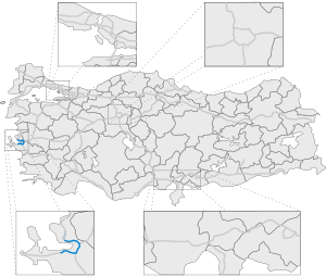
The Turkish Otoyol 30 motorway ( Turkish İzmir Çevre Otoyolu , O-30 for short ) is a part of the ring motorway around Izmir . About three quarters of the highway surrounds the coastal city. It starts in Balçova and ends in Menemen . Most of it was built on stilts and in tunnels and is therefore an expensive structure. There is no toll for the motorway.
The majority of the double-sided two-lane motorway was built between 1993 and 1998, until 2015 it was extended in stages to Menemen.
The highway was extended in stages via Aliağa to Çandarlı . Most of this motorway extension has been open to traffic since October 31, 2019, and finally the entire motorway on February 22, 2020 (see Otoyol 33 ).
