
Ottilienberg (Schorndorf)
| Ottilienberg | ||
|---|---|---|
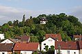
 View of the west side of the Ottilienberg |
||
| height | 347.6 m above sea level NHN | |
| location | Rems-Murr-Kreis , Baden-Wuerttemberg | |
| Mountains | Virgin forest | |
| Coordinates | 48 ° 47 '37 " N , 9 ° 31' 32" E | |
|
||
| Type | Zeugenberg | |
| rock | Keuper ; Pebble sandstone | |

The Ottilienberg is a striking 347.6 m above sea level. NHN high elevation in the southern urban area of Schorndorf . It was the site of a medieval chapel and is now a protected landscape area.
geography
The Ottilienberg is located about 1.3 km south of the Schorndorf market square about 100 m above the Remspegel as the crow flies . The Keuper - Zeugenberg , the top of which is made of harder silica sandstone , is connected to a spur of the virgin forest plateau via a saddle about 20 m deep . Especially to the west - down the rems towards Winterbach and Remshalden - it offers a good view from the highest point. In terms of natural space, it belongs to the Schurwald and Welzheimer Wald natural areas .
In the 20th century, the residential development of Schorndorf also included the lower slopes of the Ottilienberg. At the highest point there is a small pavilion, a few meters north a single house in a dominant position. Nevertheless, even today in the upper area, near-natural gardens with orchards and overgrown park-like trees offer retreat for animals and plants.
A service road that winds up the mountain leads up to the mountain, as well as a narrow path from the south that begins in the saddle.
history
In 1479 a portable altar is mentioned in a chapel dedicated to St. Ottilie , which gave the mountain its name. It was mentioned for the last time in 1537; most likely the chapel remained unused after the introduction of the Reformation in Württemberg and fell into disrepair. The description of the upper office mentions visible remains in the 19th century.
During the Thirty Years' War in 1634 imperial troops under the command of Walter Butler took advantage of the strategic location of the mountain and shot a. from here the city that burned down almost completely.
Landscape protection area
By ordinance of November 4, 1968, the top of the Ottilienberg was designated as a landscape protection area (No. 1.19.016) on an area of 8.3 hectares. To the south and west are the protected landscape area No. 1.19.064 Rehfeld, Hof, Steinmäurich, Heiligenäcker and the surrounding area , the EU bird protection area No. 7123-441 - orchards and vineyard areas between Geradstetten, Rudersberg and Waldhausen and the FFH area No. 7222 -341– Schurwald .
A group of trees on the hilltop is also recorded as a natural monument of oak and field maple as well as wood (no. 81190670046).
gallery
View from the north of the mountain
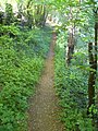
Ascent from the saddle from the south

Occurrence of the stately orchid on Ottilienberg


swell
- Guntram Palm : History of the official town of Schorndorf in the Middle Ages (writings on church and legal history, issue 11/12). Osiandersche Buchhandlung , Tübingen 1959, p. 157.
- Geographical information according to the Land Surveying Office of Baden-Württemberg : Topographic map 1: 25,000 .
Individual evidence
- ↑ Map services of the Federal Agency for Nature Conservation ( information )
- ^ Geological map of Baden-Württemberg. (Geological State Office Baden-Württemberg). Sheet 7123. 1972
- ^ Rudolph Friedrich von Moser: Description of the Oberamt Schorndorf . Ed .: Royal Statistical-Topographical Bureau. JB Müller's Verlagshandlung, Stuttgart 1851, p. 99 ( online at Wikisource ).