
Pöllwitz Forest

The Pöllwitzer Wald is a coniferous forest area in the Greiz district in Thuringia .
location
The Pöllwitzer Wald extends around Pöllwitz , today a district of Zeulenroda-Triebes . Neighboring places / districts are in the north Niederböhmersdorf and Neuärgerniß , in the east Naitschau , Erbengrün and Wellsdorf , in the south the border with the Free State of Saxony forms the administrative tree line, in the west the districts Märien and Zeulenroda extend to the tree line. The forest is located at an average altitude of ( 450 m above sea level ). Various forest locations bear the names of abandoned settlements and former hunting and forest houses. A bear was last sighted in the Pöllwitzer Forest in 1662 . Today only the village of Pöllwitz is located within the forest area. It is connected to the surrounding area by the L 2346 state road.
history
Originally the forest area belonged to the Hercynian mixed mountain forest and consisted of fir , spruce and beech in this area . The conifers were in great demand as construction timber and fuel, so the proportion of silver fir fell sharply, from an estimated 1500 to 2000 hectares in the 13th century to barely 100 hectares around 1850. Today spruce forests predominate, in various locations with larch and pine trees mixed. The planting of oaks was unsuccessful because of the soil conditions.
The Pöllwitzer forest was first mentioned in 1359 as "horned" and in the high Middle Ages belonged to the rulership of the bailiffs of Weida . The partition contract signed by the Russians Heinrich the Elder von Obergreiz , Heinrich the Middle von Schleiz and Heinrich Posthumus von Gera in 1596 regulated the use of the forest. Gera, about 30 kilometers away, was particularly keen to acquire the forest. In 1603 the Gera rulers bought the village of Pöllwitz von Greiz in order to control the forest management on site. A ten-year contract for the construction of a raft ditch to the White Elster was negotiated. On this basis, the city of Gera was able to obtain up to 1500 fathoms of logs annually by water (Flößgraben → Triebes → Weida → Weisse Elster). Only particularly valuable trunks were transported by land; charcoal , pitch and honey were also produced in the Pöllwitzer Wald and delivered to Gera.
The raft timber ditch required regular maintenance, a sophisticated system of ponds, footbridges, mule tracks and weirs was created. The Gera council had to pay fees to the neighboring gentlemen for these rights of use. The expansion of the Pöllwitzer pond alone was charged with 514 guilders. On the other hand, the transport costs for the wood from the northern area around Gera were many times higher, since only overland transport was possible here. At the end of the Thirty Years' War , the value of the forest increased enormously as many places needed lumber. The neighboring communities on Flößgraben closed the ditch with reference to outstanding payments, which was made impassable in several places. The Geraer reacted indignantly and dispatched armed servants to put the fairway back into operation. The sovereign put pressure on both sides and brought about an arbitration. The Gera councilors gave in and initiated the construction of a second raft wood trench on an alternative route. From 1665 to 1700, up to 3,000 fathoms of logs came to Gera and met the city's needs. Gera trading companies bought the rafts that only arrived in the spring and thus controlled the wood price in their favor. Occasionally the wood was also rafted to downstream locations in the Altenburger Land that were in "wood shortage". In 1825 the rafting was stopped on the Triebes.
The overexploitation of the forest became apparent, since the focus was on natural regeneration and the neighboring villages were still allowed to exercise their rights of drift. The western part of the forest in particular became a heathland . It was not until 1800 that the forestry yield regulation began with an overall survey of the forest and division into rectangular forest divisions of equal size. At that time, the forest still had a total area of 6036 acres (37.847 acres in the Principality of Reuss).
From 1964, the NVA was assigned a part of the forest as a shooting range. In this context, several forest houses and forest workers' houses had to be abandoned. The military had this restricted area until 1990 . Among other things, it was used to train the GDR's border troops .
The population only regained access to this part of the forest after the military area had been decontaminated . Hiking trails and various nature trails were created. The Thuringian State Forest Administration is responsible for the economic use of the state forest .
tourism
The Pöllwitzer Wald is of great importance as a local recreation area and for "soft tourism" . Parts of the area are designated as an FFH nature reserve and thus receive scientifically justified usage restrictions that are defined according to location and scope.
A tourism concept from 2008 dealt with the development of the sights distributed over the entire forest area and referred to the lack of accommodation options.
natural reserve
The FFH area Pöllwitzer Wald (No. 150) covers a total area of 962 hectares. The area was reported to the European Commission in 2000 . In 2015, the Pöllwitzer Wald and adjacent heathland areas were transferred to DBU Naturerbe GmbH .
photos
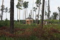
Lookout tower in the moor experience area in the Pöllwitzer Forest
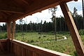
View of part of the ring-shaped catwalk in the moor experience area


Individual evidence
- ^ Regional management of the Greiz region: Tourism conception “Landkreis Greiz”, as of April 2008. (PDF) Archived from the original on June 1, 2016 ; accessed on June 11, 2017 .
- ↑ DBU: Foundation subsidiary protects Pöllwitzer Wald . October 22, 2015 ( dbu.de [accessed November 11, 2018]).
literature
- The northern Vogtland around Greiz . A geographical inventory in the area of Greiz, Weida, Berga, Triebes, Hohenleuben, Elsterberg, Mylau and Netzschkau. In: Leibniz Institute for Regional Geography (Ed.): Landscapes in Germany . tape 68 . Böhlau Verlag, Leipzig 2006, ISBN 3-412-09003-4 , Pöllwitz with Pöllwitzmühle, since 1994 on Vogtländisches Oberland, district of Greiz, and Pöllwitzer Wald, p. 229-232 .
Web links
- Thuringian State Institute for Environment and Geology: Nature reserves in the district of Greiz
Coordinates: 50 ° 38 ′ 14 " N , 12 ° 3 ′ 56" E