Pantabangan
| Municipality of Pantabangan | ||
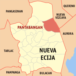
| Location of Pantabangan in the province of Nueva Ecija | ||
|---|---|---|

|
||
| Basic data | ||
| Region : | Central Luzon | |
| Province : | Nueva Ecija | |
| Barangays : | 14th | |
| District: | 2. District of Nueva Ecija | |
| PSGC : | 034920000 | |
| Income class : | unknown (1-6) | |
| Households : | 4808 May 1, 2000 census
|
|
| Population : | 29,925 August 1, 2015 census
|
|
| Coordinates : | 15 ° 49 ′ N , 121 ° 9 ′ E | |
| Postal code : | 3124 | |
| Mayor : | Romeo Villajuan Borja Sr. | |
| Geographical location in the Philippines | ||
|
|
||
Pantabangan is a Filipino municipality in the Nueva Ecija Province . It has 29,925 inhabitants (August 1, 2015 census). The community is located in the southeast of the Caraballo Mountains , at the transition to the Sierra Madre massif , in the east, and the Central Luzon Plain in the west. The Pantabangan reservoir , which is one of the largest in the country, is located in the municipal area .
Barangays
Pantabangan is politically divided into 14 barangays .
- Cadaclan
- Cambitala
- Conversion
- Ganduz
- Liberty
- Malbang
- Marikit
- Napon-Napon
- Poblacion East
- Poblacion West
- Sampaloc
- San Juan
- Villarica
- Fatima
