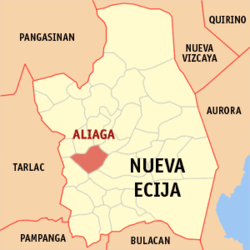
Aliaga (Philippines)
| Municipality of Aliaga | ||
| Location of Aliaga (Philippines) in the Nueva Ecija Province | ||
|---|---|---|

|
||
| Basic data | ||
| Region : | Central Luzon | |
| Province : | Nueva Ecija | |
| Barangays : | 26th | |
| District: | 1. District of Nueva Ecija | |
| PSGC : | 034901000 | |
| Income class : | 2nd income bracket | |
| Households : | 9849 May 1, 2000 census
|
|
| Population : | 63,543 August 1, 2015 census
|
|
| Population density : | 620.8 inhabitants per km² | |
| Area : | 102.36 km² | |
| Coordinates : | 15 ° 30 ′ N , 120 ° 51 ′ E | |
| Postal code : | 3111 | |
| Mayor : | Marcial R. Vargas | |
| Geographical location in the Philippines | ||
|
|
||
Aliaga is a Philippine municipality in the province of Nueva Ecija .
Aliaga is located on the island of Luzón about 113 km northwest of Manila halfway between the Pampanga and Chico rivers in a large and fertile valley.
The most important agricultural products are corn , rice , sugar and tobacco .
The most important language is Tagalog , and Ilocano , Pampango and Pangasinian are also spoken. In Barangay Bibiclat there is a Laboratory High School of Central Luzon State University .
Barangays
Aliaga is politically divided into 26 barangays .
|
|
