Gabaldon (Nueva Ecija)
| Municipality of Gabaldon | ||
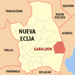
| Location of Gabaldon in the province of Nueva Ecija | ||
|---|---|---|

|
||
| Basic data | ||
| Region : | Central Luzon | |
| Province : | Nueva Ecija | |
| Barangays : | 16 | |
| District: | 3. District of Nueva Ecija | |
| PSGC : | 034907000 | |
| Income class : | 3rd income bracket | |
| Households : |
May 1, 2000 census
|
|
| Population : | 35,383 August 1, 2015 census
|
|
| Population density : | 145.7 inhabitants per km² | |
| Area : | 242.88 km² | |
| Coordinates : | 15 ° 28 ′ N , 121 ° 19 ′ E | |
| Postal code : | 3131 | |
| Geographical location in the Philippines | ||
|
|
||
Gabaldon ( Tagalog : Bayan ng Gabaldon ) is a Filipino municipality in the province of Nueva Ecija , in the administrative region III, Central Luzon. Gabaldon has 35,383 residents (August 1, 2015 census) who lived in 16 barangays . It is classified as a third income class community in the Philippines and as partially urbanized . It was founded on January 31, 1901.
Gabaldon is located in the middle of the Sierra Madre mountain range . Their neighboring communities are Bongabon in the north, Laur in the west, General Tinio in the south and Dingalan in the east.
The provincial capital Palayan City is about 11 kilometers west and Manila about 111 kilometers south of Gabaldon.
Barangays
|
|
