Saint Peter and Saint Paul Rocks
| Saint Peter and Saint Paul Rocks | |
|---|---|
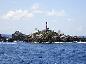
| Lighthouse and hut on the island of Belmonte ( Sudoeste ) | |
| Waters | Atlantic Ocean |
| Geographical location | 0 ° 55 ′ N , 29 ° 21 ′ W |
| Number of islands | 5 (+ numerous small rocks) |
| Main island | Belmonte |
| Total land area | 0.013 km² |
| Residents | 4 (scientific staff) |
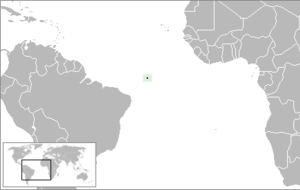
| Map of the archipelago | |
The Saint Peter and Saint Paul Rocks ( Portuguese: Arquipélago de São Pedro e São Paulo ) are a small group of bare rock islands located about 960 km off the northeast coast of Brazil in the Atlantic . From a meteorological point of view, the archipelago, located about 100 km north of the equator, is in the intra-tropical convergence zone all year round .
geography
The group measures around 250 to 300 m in diameter and is 18 m high at its highest point (on the largest island, Belmonte). It has a total area of 1.3 ha (0.013 km²). The closest island is Fernando de Noronha, about 625 km southwest .
The following islands belong to the archipelago:
- Ilha Belmonte (Sudoeste, southwest): 5380 m²
- Ilha Challenger (São Paulo, southeast): 3000 m²
- Ilha Nordeste (São Pedro, northeast): 1440 m²
- Ilhota Cabral (Noroeste, northwest): 1170 m²
- Ilhota Sul (Sul, south): 943 m²
as well as small rocks like Rocha Beagle and Rocha Pillar in the north, Rocha Cambridge in the east and Rocha Coutinho and Rocha Erebus in the south. There is no fresh water on any of the islands .
geomorphology
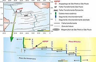
The Sankt-Peter-und-Sankt-Pauls-Felsen are the tip of a large underwater elevation that measures 90 kilometers east-west and 21 kilometers north-south along the 3000 meter depth line . In the ground plan, this sigmoidal, morphological high forms an "S" tilted to the right, the north and south edges of which are built up by east-west oriented back structures. The north ridge with the archipelago sitting on it is higher than the south ridge and rises above sea level. The south ridge reaches a depth of almost 1,400 meters. A rift valley runs between the two ridges , which is deeper than 2,700 meters.
The high structure, interpreted geologically as a megamullion , belongs to the northern edge of the approximately 90-kilometer-wide, N 080-striking St. Paul Fracture Zone , which gradually shifts the Mid-Atlantic Ridge to a total of 550 kilometers to the east. The northern segment with the archipelago, which is only 25 kilometers wide, has a left-sided offset of 280 kilometers. The north ridge is directly adjacent to the northernmost transform fault within the fracture zone. The Mid-Atlantic Ridge is about 120 kilometers to the west, and it is 160 kilometers to its segment, which is offset to the east.
geology
In contrast to most of the islands in the Atlantic, such as Iceland , Jan Mayen , the Azores , Ascension and Tristan da Cunha , which are all of purely volcanic origin , the Saints Peter and Saint Pauls rocks consist of ultramafic mantle rock ( peridotite ) . Due to the immediate proximity of the northern marginal fault that bounds the fracture zone, the peridotite was heavily tectonized, mylonitisized and metasomatically converted into serpentinite . The north ridge is traversed by countless steep faults in an east-west direction, which, in addition to a right-hand offset, also have a suspensive component and thus explain the tectonically induced pressure on the archipelago. The faults are occasionally accompanied by Gabbroic intrusions, and lavas also emerged from them from a water depth of 1200 meters.
The rift zone adjoining to the south is underlain by slightly deformed, serpentinitized peridotite. It contains basaltic lavas and dolerite intrusions . The rift system may have originated as a pull-apart.
The southern ridge, like the ditch, consists of undeformed, serpentinitized peridotite. Platform-like sponge colonies have settled on its north side and sediments were left in the south, which formed a solidified, calcareous crust coating on the serpentinites.
Inside the Challenger Island, a 40 × 70 meter pocket of Quaternary sediments has been preserved - the Saint Peter and Saint Paul Formation . The formation is divided into two units, the Atobás member lying on the floor and the Viuvinhas member lying on the wall . The Atobás member lies discordantly with a transgression conglomerate of angular to rounded peridotite pebbles over the peridotitic substructure. The clast size is reduced to the hanging wall via conglomeratic arenites to coarse to medium arenites (sand fraction). The Viuvinhas member sedimented after a hiatus consists of calcarenites with reconditioned clasts of biogenic origin. It also sets in conglomerate and then loses its clast size towards the hanging wall.
The Saint Peter and Saint Paul Formation provides evidence of seismic events during their deposition. Three major events can be identified:
|
Even Late Pleistocene to Holocene Abrasionsterrassen reveal to the Saint Peter and Saint Paul Archipelago. Polymictic beach pebbles can be found at levels 3, 6, 9 and 15 meters, roughly comparable to the conditions in the Fernando de Noronha archipelago. They illustrate a jerky lifting of the archipelago in the Upper Quaternary. The terraces of the 6 and 9 meter level can be assigned to the Flandrian (Holocene) and are about 6000 years old. This results in a rather high uplift rate of 1.5 millimeters per year. Age dating with the radiocarbon method on fossil corals yielded comparable results. The mantle peridotite is likely to have been raised by 10 kilometers with normal oceanic crust thickness . This means that uplift began around 7 million years ago . However, the actual island stage was only reached in the Young Pleistocene 100,000 to 200,000 years ago.
Political Affiliation
Brazil maintains a beacon and a hut for military personnel and researchers on the islands . Administratively, they belong to the Brazilian state of Pernambuco , although closer to the mainland of the state of Rio Grande do Norte .
Wildlife
Seabirds such as white-bellied gannets ( Sula leucogaster ), noddis ( Anous stolidus ) and lesser noddy tern ( Anous minutus ) breed on the rocks , as well as red cliff crabs ( Grapsus grapsus ).
Events
- The islands were visited by Charles Darwin on February 16, 1832 during his expedition with the Beagle .
literature
- Thomas Ferreira da Costa Campos u. a .: Saint Peter and Saint Paul's Archipelago - Tectonic uplift of infra-crustal rocks in the Atlantic Ocean . In: Manfredo Winge u. a. (Ed.): Geological and Palaeontological Sites of Brazil (SIGEP) . 2005 (English, online [PDF; 1.4 MB ]).
- Karl Brocks, Ernst W. Lemke: The landing on the St. Pauls rock . In: Eugen Seibold, Gerhard Zickwolff (Ed.): Research ship Meteor 1964–1985 . German Research Foundation, German Hydrographic Institute, Bremerhaven 1985, p. 127–129 ( online [PDF; 11.4 MB ]).
Web links
- Wolfgang Schippke: Saint Peter & Saint Paul Felsen (SA-014).
- Islands in the Atlantic Ocean about halfway between South America and Africa. World Wide Fund For Nature (English).
- Image of the researcher's hut and the lighthouse ( memento from April 9, 2008 in the Internet Archive ).
Individual evidence
- ↑ Programa Arquipélago de São Pedro e São Paulo. Estação Científica . Comissão Interministerial para os Recursos do Mar, accessed 24 September 2016 (Portuguese).
- ↑ Roger Hekinian et al. a .: Submersible observations of Equatorial Atlantic mantle: The St. Paul Fracture Zone region . In: Marine Geophysical Researches . tape 21 , 2000, ISSN 0025-3235 , p. 529-560 , doi : 10.1023 / A: 1004819701870 (English).
- ↑ Thomas Ferreira da Costa Campos u. a .: Tectonic and eustatic significance of the Quaternary St. Peter and St. Paul Formation, equatorial Atlantic . In: International Association of Sedimentologists (Ed.): 23rd IAS Meeting of Sedimentology (Abstracts Book) . 2004, ISBN 972-9119-25-2 , pp. 77 (English, available online through researchgate.net ).
- ↑ Akihisa Motoki et al. a .: Taxa de soerguimento atual do arquipélago de São Pedro e São Paulo, Oceano Atlântico Equatorial . In: Revista Escola de Minas . tape 62 , no. 3 , 2009, ISSN 0370-4467 , p. 331-342 , doi : 10.1590 / S0370-44672009000300011 (Portuguese).


