Penschinabusen
| Penschinabusen Пе́нжинская губа́ |
|
|---|---|
| Waters | Sea of Okhotsk |
| Land mass | East Asia, Kamchatka Peninsula |
| Geographical location | 61 ° 15 ′ N , 163 ° 0 ′ E |
| width | 100 km |
| depth | 300 km |
| Tributaries | Kechitschma , Paren , Tylchoi , Chaimikina , Mikina , Penschina , Talowka , Mamet , Kuiwiwajam , Rekinniki , Pustaja |
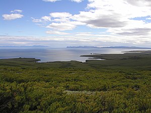
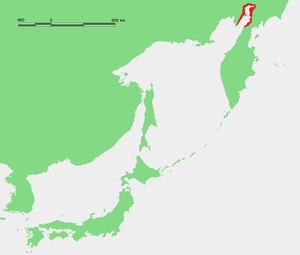
As Penzhina Bay ( Russian Пенжинская губа / Penschinskaja guba ) is the northeastern An accounting processing of a main arm of the great shelikhov gulf referred to the northeastern part of the Sea of Okhotsk in the Far East of Russia forms.
The approximately 300 km long Peninsula Bay extends between the northern part of the Kamchatka Peninsula in the east and the Taigonos Peninsula in the west. On average, the bay is 65 km wide, between Cape Taigonos at the tip of the peninsula of the same name and Cape Dalni and Cape Boschedomowa on the opposite side of the west coast of Kamchatka . Approximately in the middle of the Penschinabusens peninsulas protrude far into the bay from the east and west, so that their width here is only about 30 km. The Mametschinski peninsula on the east coast between the northern Cape Mamet and the southern Cape Wodopadny , 30 km away, rises with the Bolshoi Mamet mountain to 990 m above sea level. The Jelistratow Peninsula on the west side is flatter (up to 475 m ), but larger, and has more indented banks with several islands in front of them. The maximum water depth of the Peninsula bus is 80 m at the level of Cape Taigonos, and 125 m in a narrow channel between the Mametschinski and Jelistratow peninsula.
Two important rivers flow into the inner part of the bay, the eponymous Penschina and a few kilometers south the Talowka . Other rivers that flow into the bay (from west to east) are Kengewejem (or Gorelowka ), Talnawajam (or Aitschan ), Ketschitschma , Paren , Tylchoi and Mikina on the west side and Kuiwiwajam , Rekinniki and Pustaja on the east side.
The tidal range in the Peninsula Bay reaches maximum values for the entire Pacific Ocean and its tributaries : an average of 9 m, a maximum of 12.9 m. The bay freezes over between late October and April.
Administratively, the extremely sparsely populated coastal area around the Penschinabusen mostly belongs to the Penschinski Rajon of the Kamchatka Region (before July 1, 2007, the Koryak Autonomous Okrug ). Here are the only two villages near the coast of the Penschina bus: Manily with a good 900 inhabitants on the right bank of the Penschina not far from its mouth and Paren with less than 100 inhabitants at the mouth of the river of the same name that flows into the bay from the northwest. The uninhabited coast of the Taigonos peninsula to the Peninsula Bay belongs to the Severo-Evensky Rajon of the Magadan Oblast .
Because of the strong tides , the Peninsula Bay came into focus as a possible location for a huge tidal power station as early as the Soviet period . Depending on the location, a possible output of up to 87 gigawatts was calculated. In addition to technical problems and costs, the lack of infrastructure and potential energy consumers in the area prevent the implementation of such a project.
Web links
- Article Penschinabusen in the Great Soviet Encyclopedia (BSE) , 3rd edition 1969–1978 (Russian)
Individual evidence
- ↑ Article about tidal power plants ( page no longer available , search in web archives ) Info: The link was automatically marked as defective. Please check the link according to the instructions and then remove this notice. in Wokrug Sweta , March 2009


