
Pfedelbach (Ohrn)
|
Pfedelbach upper course: Lohklingenbach lower course: Schleifbach |
||
 The Pfedelbach is the outflow of the Buchhorner See. |
||
| Data | ||
| Water code | DE : 23867872 | |
| location |
Swabian-Franconian forest mountains
|
|
| River system | Rhine | |
| Drain over | Ohrn → Kocher → Neckar → Rhine → North Sea | |
| origin | Outflow of the Buchhorn lake in the Pfedelbach district of Buchhorn 49 ° 9 ′ 15 ″ N , 9 ° 30 ′ 6 ″ E |
|
| Source height | 377 m above sea level NN | |
| muzzle | In Öhringen from the left into the Ohrn coordinates: 49 ° 12 '7 " N , 9 ° 29' 48" E 49 ° 12 '7 " N , 9 ° 29' 48" E |
|
| Mouth height | approx. 223 m above sea level NN | |
| Height difference | approx. 154 m | |
| Bottom slope | approx. 23 ‰ | |
| length | 6.6 km | |
| Catchment area | 12.8 km² | |
| Reservoirs flowed through | Buchhorner See | |
| Residents in the catchment area | 9000 | |
The Pfedelbach is a brook in Pfedelbach in the Hohenlohe district in northern Baden-Württemberg , which flows into the Ohrn from the left after running for almost 7 km in Öhringen . It is called Lohklingenbach on the upper course and Schleifbach on the lower course .
geography
origin
The Pfedelbach rises at about 377 m above sea level. NN in the northern Mainhardt Forest the Buchhorner See in the Pfedelbach suburb of Buchhorn . In this area he is also called Lohklingenbach. Below Buchhorn he has dug a narrow, north-north-west oriented forest gorge.
Upper course to Pfedelbach
In the area of the Lohklinge the Pfedelbach flows between Frauenberg and Burgberg to the local border of Pfedelbach. It feeds a fish farm in the Gewann Oberer Weiler. In the neighboring village of Pfedelbach, the Pfedelbach is partially overturned; the canal crosses under the main street and flows under the Marstall building, parallel to and then under the Kirchgasse and finally emerges north of the sports field again to the surface.
Lower course from Pfedelbach
From Pfedelbach, the Pfedelbach flows between the L 1050 and the western bypass, past the Öhringer cemetery, parallel to Schleifbachweg to the confluence at the Schleifbachweg / Herrenwiesenstraße intersection. In the lower reaches of Öhringer, the Pfedelbach is also called Schleifbach .
Catchment area
The Pfedelbach drains an area of 12.8 km² to the Ohrn, of which about a fifth in the north on the lower reaches of the town of Öhringen belongs, while the rest is on Pfedelbacher municipality markings. The southern third belongs to the natural area of the Swabian-Franconian Forest Mountains , which stretches an approximately 3 km long lead to the northeast between the valleys of Brettach in the west and Ohrn in the east, the other two thirds of the Hohenlohe plain .
The catchment area of the Pfedelbach has roughly the shape of a north-south oriented spindle, the northernmost point of which is at the confluence near the Öhringen old town and the southernmost point between Buchhorner See and Geddelsbach close to the eaves of the Brettach valley.
From there, the watershed runs on this first northwest, then soon north of the eastern edge of the Eichhalde past the eastern Lindelberg and on the ridge of the Golberg to the eastern Verrenberg , where the most northwestern point is reached. Beyond that, the Brettach flows roughly parallel at a short distance, whose right tributaries between Geddelsbach and Bitzfeld are the direct competitors of Pfedelbach .
From this point on the watershed runs all the way back to the south against the Ohrn; initially a short distance northeast to the mouth, there is no open drain beyond in the western Öhringen urban area. Then the dividing line bends to the southeast and runs as far as the Öhringer water tower on the northern Pfaffenturm, also here without immediate competitors other than the Ohrn itself. Then the border runs through the easternmost Pfedelbach to the south to about Pfedelbacher Wohnplatz Lerchen, here again has the east no manifest tributaries very near Ohrn.
Then the watershed curves around the Baierbach, which runs towards the Ohrn, to the west and back again, in the first half of which it climbs up the ridge of the Charlottenberg to Heuberg, which it cuts through, and then in the second, a little west of the L 1050, to the ridge of the Buchhorner To follow the northwest spur of the Mainhardt Forest and to reach the southernmost point via the birch forest ; The immediate competitor here is the aforementioned Baierbach .
In the catchment area of the Pfedelbach , in addition to a few small settlement areas, there are the villages of Buchhorn, Heuberg (partially), Pfedelbach, Windischenbach and a sector of the southern Öhringen.
Tributaries
Outflow of the Pfedelbach , here called Lohklingenbach , from the 2.0 hectare Buchhorner See at 377 m above sea level. NN .
- Merzenbächle , from the right at the roundabout at the Pfedelbacher sports field, 1.4 km and 2.0 km². Arises on the south-eastern outskirts at the cemetery and runs in an east arch to the underground mouth, from the Kelterstraße verdolt.
- Dengelsgraben , from the right shortly after the end of the industrial area in the north of Pfedelbach and the crossing of the Pfedelbach to Öhringer district, 1.3 km and 1.0 km². Arises from several branches on the western slope of the Pfaffenberg and runs through the wide Hannenklinge to the mouth.
-
Windischenbach , from the left at the southern Öhringer industrial zone around the street Am Steinsfeldle, 3.7 km and 4.5 km². Arises in the wooden blade that separates the mountain spur that ends in the castle hill north from the tan blade in the east.
- Inflow from the direction of the Eichhalde , from the left on the southern edge of the village of Windischenbach , 1.1 km.
- Inflow from the southern foot of the Golberg , from the left in the center of Windischenbach, 1.1 km.
The mouth of the Pfedelbach as Schleifbach from the left into the Ohrn in Öhringen at the confluence of the Schleifbachweg in the Herrenwiesenstraße.
Places and settlement areas on the run
- municipality Pfedelbach
- Buchhorn district
- Pfedelbach village
- City of Öhringen
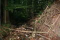
The Lohklinge with the Pfedelbach (called Lohklingenbach here) in Pfedelbach-Buchhorn
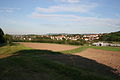
View from Holzbühl to the Gewann Oberer Weiler, in the background the village of Pfedelbach

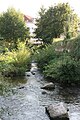
The bridge over the Pfedelbach at the north-western entrance to Öhringen
The mouth of the Pfedelbach (here called Schleifbach) in the Ohrn in Öhringen
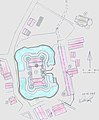
Site plan of the castle in Pfedelbach with the course of the Pfedelbach in this area


geology
The Buchhorner See, from which the Pfedelbach rises, is located on the silica sandstone plateau ( Hassberge Formation ) in the northern parts of the Mainhardt Forest. At the beginning of the Lohklinge , the outflowing brook enters the Lower Bunter Marl ( Steigerwald Formation ), in the Klinge it later runs very briefly through the reed sandstone ( Stuttgart Formation ) before it reaches the Gipskeuper ( Grabfeld Formation ) in the second half in which it then remains almost up to the mouth. Only a few hundred meters before this covers the flat right valley hill in Öhringen Lettenkeuper ( Erfurt formation ). The layers on the Hohenlohe plain are overlaid by loess in many places , preferably on the eastern slopes in the valleys, i.e. in the direction of delivery in leeward direction . The floodplain filling is very wide between the Merzenbächle and Windischenbach tributaries.
The origin of the Windischenbach in the Holzklinge lies in the lower colored marl, all other tributaries to Pfedelbach and Windischenbach begin in the Gipskeuper.
To the north of the castle hill, reed sandstone spreads out extensively, further before the western hill at the exit of the wooden blade ; it also forms the ceilings of the witness mountains Lindelberg and Golberg on the western edge of the catchment area, off the Keuperberge , which continue beyond the watershed.
Individual evidence
- ↑ Sea level of the Buchhorner See according to TK25 (black) and geodata viewer (blue).
- ↑ estimated according to the course of the contour lines on the TK25 in the two valley hollows.
- ↑ According to LUBW-FG10 (data record entry).
- ↑ Sum of the sub-catchment area according to LUBW-GEZG (data record entries).
- ^ Geology according to GK50-SFW.
literature
- "TK25": Topographic map 1: 25,000 Baden-Württemberg North, as single sheet no. 6823 Pfedelbach
- "GK50-SFW": Geological map of the Swabian-Franconian Forest Nature Park 1: 50,000, published by the State Office for Geology, Raw Materials and Mining Baden-Württemberg, Freiburg i. Br. 2001
Web links
Geoportal Baden-Württemberg ( information ), especially with the partial maps / layers
- the State Institute for the Environment, Measurements and Nature Conservation Baden-Württemberg (LUBW)
- "LUBW-FG10": River 1: 10,000
- "LUBW-SG10": Standing water 1: 10,000
- "LUBW-GEZG": water catchment areas
- of the State Office for Geology, Raw Materials and Mining of the State of Baden-Württemberg (LGRB)
- "LGRB-GÜK300": Geological overview map 1: 300,000