Piaśnica (river)
|
Piaśnica Piasnitz |
||
|
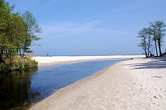
The Piaśnica near Dębki |
||
| Data | ||
| location | Polish Pomeranian Voivodeship | |
| River system | Piaśnica | |
| River basin district | obszar dorzecza Wisły | |
| source | near Mała Piaśnica ( Klein Piasnitz ) 54 ° 38 ′ 40 ″ N , 18 ° 16 ′ 3 ″ E |
|
| muzzle | west of Dębki in the Baltic Sea Coordinates: 54 ° 50 ′ 1 ″ N , 18 ° 3 ′ 45 ″ E 54 ° 50 ′ 1 ″ N , 18 ° 3 ′ 45 ″ E
|
|
| length | approx. 28 km | |
| Catchment area | approx. 310 km² | |
The Piaśnica ( German Piasnitz , formerly Piasznitz , Piaschnitz ), Kashubian Piôsznica , is an approximately 28 kilometers long coastal river in the Polish Pomeranian Voivodeship , which flows into the Baltic Sea north of Lake Zarnowitz .
course

The entire river bed of the Piaśnica from the headwaters to the confluence with the Baltic Sea is located in the former West Prussia . The catchment area of the Piaśnica is about 310 km², of which 80% are in West Prussia and the rest in Western Pomerania , in the former district of Lauenburg i. Pom.
The Piaśnica rises north of Neustadt ( Wejherowo ) in the Starsiner Forest near the village of Klein Piasnitz ( Mała Piaśnica ) First it flows in an arc to the northwest, then turns east of the village of Rieben ( Rybno ) to the north, flows through the Zarnowitz lake , leaves it to the west of the Zarnowitz Monastery and flows into the Baltic Sea, crossing the Zarnowitzer Bruch in two arms, west of the fishing village Dembeck ( Dębki ). After a run of about 28 kilometers, the Piasnitz is only about ten meters wide and is not navigable.
As with other West Prussian coastal rivers and streams, the confluence of the Piasnitz is peculiar in that the river does not flow straight into the sea in the immediate vicinity of the beach, but rather slopes to the east and only pours into the sea a distance further east. This peculiarity, with which the mouth tends to become blocked, is caused by the coastal current of the sea, driven by westerly winds, which leads to sanding. With higher storm surges , the Piasnitz confluence is usually warped and silted up.
In its lower course, the flow rate of the Piaśnica is 1.5 m³ of water per second. The western branch of the Piasnitz estuary formed the border between the Province of Pomerania and the Province of West Prussia until 1919, and from 1920 to 1939 the border between the Pomerania and the Polish Corridor .
literature
- Hans Prutz : History of the Neustadt district in West Prussia . Danzig 1872, p. 4.
Footnotes
- ^ A b c d Hans Prutz : History of the Neustadt district in West Prussia . Danzig 1872, p. 4.
- ↑ Berthold Benecke : Fish, fishing and fish farming in East and West Prussia . Königsberg 1889, p. 237.
- ^ Leopold von Zedlitz-Neukirch : The state forces of the Prussian monarchy under Friedrich Wilhelm III. , Volume 1, Berlin 1828, p. 212.
- ^ Friedrich Benedict Weber : Handbook of state economic statistics and administrative studies of the Prussian monarchy . Breslau 1840, p.28.
- ↑ GCA Krause: The dune building on the Baltic Sea coasts of West Prussia. A practical textbook. Along with a coast map and 6 sheets with explanatory drawings . Berlin 1850, pp. 25-26.
- ↑ Otto Baensch : The storm surge on 12./13. November 1872 on the Baltic coast of the Prussian State . In: Zeitschrift für Bauwesen , Volume 25, Berlin 1875, Columns 155–220, especially column 201.
