
Piz Linard (Lantsch / Lenz)
| Piz Linard | ||
|---|---|---|
 Piz Linard and Lenzer Horn , recorded by Riom . |
||
| height | 2767 m above sea level M. | |
| location | Canton of Graubünden , Switzerland | |
| Mountains | Plural pen | |
| Dominance | 0.74 km → Lenzer Horn | |
| Notch height | 77 m ↓ ridge between Piz Linard and Lenzer Horn | |
| Coordinates | 764 999 / 174352 | |
|
||
 Summit of Piz Linard |
||

The Piz Linard (attributed to ‹ Leonhard ›) is a mountain north of Tiefencastel and southeast of Lenzerheide in the canton of Graubünden in Switzerland at an altitude of 2767 m above sea level. M. The sloping down from the summit bare scree slopes are very well visible from the Julier Pass via Tiefencastel.
Location and surroundings
The Piz Linard belongs to the Lenzer Horn - Erzhorn chain , a subgroup of the plural pen . The municipal boundary between Albula / Alvra and Lantsch / Lenz runs above the summit . The Piz Linard is bordered in the southeast by the Albula valley and in the west by the Lenzerheide valley. At the southern foot of the Piz Linard, the two valleys also meet the Oberhalbstein in the south and the Schin in the west .
The neighboring peaks include the Lenzer Horn in the north, the Piz Mosch in the northeast and the Piz Mulain in the east.
The most distant visible point ( 46 ° 28 ′ 0.7 ″ N , 7 ° 59 ′ 29.5 ″ E ) from Piz Linard is located 255 m northwest of the Aletschhorn in the canton of Valais and is 125.3 km away.
The valley locations are Brienz / Brinzauls and Lantsch / Lenz .
Routes to the summit
Over the east side
- Starting point: Brienz / Brinzauls ( 1142 m )
- Via: Pigni ( 1430 m ), Hetta da las Nuorsas ( 1982 m ), Culmatsch ( 2506 m )
- Difficulty: EB / T3
- Time required: 4 hours
Over the south ridge
- Starting point: Lantsch / Lenz ( 1328 m )
- Via: Zurtail, Propissi ( 1817 m ) and Schautschen ( 1863 m )
- Difficulty: EB / T3
- Time required: 3 ¾ hours
Over the north ridge
- Starting point: Lenzer Horn ( 2905 m )
- Difficulty: BG
- Time required: 1 ½ hours
- Note: Routes to the Lenzer Horn, see the article Lenzer Horn
panorama
_Panorama.jpg)
gallery

The Piz Linard, taken from the Lenzer Horn
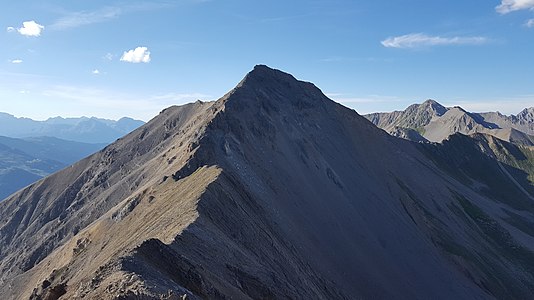
Looking north to the Lenzer Horn
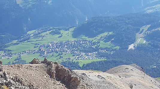
Look down to Lenz


literature
- Bernard Condrau, Manfred Hunziker: Club guide, Bündner Alps . Tamina and Plessur Mountains. 4th edition. tape I . Verlag des SAC, 1981, ISBN 3-85902-048-X , p. 317-318 .
- National map of Switzerland, sheet 1216 Filisur, 1: 25,000, Federal Office of Topography, 2015 edition.
Web links
- Calculated 360 ° panorama from Piz Linard
- Tour reports on www.hikr.org
Individual evidence
- ↑ Andrea Schorta: How the mountain got its name . Small Rhaetian name book with two and a half thousand geographical names of Graubünden. Terra Grischuna Verlag, Chur and Bottmingen / Basel 1988, ISBN 3-7298-1047-2 , p. 99 .
- ↑ Calculated 360 ° panorama ( U. Deuschle ; information ) from Piz Linard