
Place Denfert-Rochereau
| Place Denfert – Rochereau | |
|---|---|
| location | |
| Arrondissement | 14th |
| quarter | Montparnasse Petit-Montrouge |
| Junctions | Boulevard Raspail Rue Froidevaux Rue de Grancey Avenue du Général-Leclerc Avenue René-Coty Boulevard Saint-Jacques Boulevard Arago Avenue Denfert-Rochereau Avenue du Colonel-Henri-Rol-Tanguy |
| morphology | |
| length | 220 m |
| width | 145 m |
| history | |
| Emergence | around 1760 |
| designation | August 16, 1879 |
| Original names | Place d'Enfer (-1879) |
| Coding | |
| Paris | 2703 |

The Place Denfert-Rochereau , formerly Place d'Enfer , is a place in the Paris district Montparnasse , in the 14th arrondissement .
location
The square is planted with trees on the edge and surrounded by three small parks. It is an important transport hub for both road and rail traffic, served by the bus routes 38, 68, 88, N14 and Orlybus operated by the RATP . The Denfert-Rochereau transfer station is located under the square with stops for the metro lines and and the RER and .
![]()
![]()
![]()
![]()
![]()
![]()
The street section that crosses the southern part of Place Denfert-Rochereau and leads to Avenue du Général-Leclerc has been named Avenue du Colonel-Rol-Tanguy since 2004 in honor of the head of the resistance organization Francs-tireurs et partisans Henri Tanguy (code name Rol), whose command center was in the quarries partly located under the square during the Second World War .
On this short avenue, two customs houses, designed by Claude-Nicolas Ledoux in the 1780s, face the former wall of the general tenants ( Mur des Fermiers généraux in French ), to the east of which is the entrance building of the catacombs of Paris . At the time, they flanked the Barrière d'enfer customs barrier, named after the nearby Rue d'Enfer (today avenue Denfert-Rochereau ), and housed the office of the gatekeeper responsible for collecting city customs (see: Excise ). ( * )
Original names

It has been named after Pierre Philippe Denfert-Rochereau since 1879 , who successfully defended the Belfort fortress against the attacking Prussians in the Franco-Prussian War of 1870/71 .
history
This square owes its opening as part of the Boulevards du Midi to the patent letter of August 9th, 1760 for the part that was inside the former tenant wall (northeastern part of the square) and the order of the Bureau des Finances of January 16, 1789 for the part that was outside the former customs wall (south-western part of the square). This crossing at the (city) customs wall, which led to or from Paris, was called "Barrière d'Enfer" ( German hell barrier ) by the population .
In 1774, several landslides followed one another as forgotten underground Parisian quarries collapsed, and streets and buildings buried.
After the wall of the general tenants was demolished by Haussmann , the part of the square in the south of today's Boulevards Saint-Jacques and Raspail , which previously belonged to the municipality of Montrouge, was added to the urban area of Paris.
In the center of the square there are still the two buildings designed by Claude-Nicolas Ledoux that make up this gate in the wall of the Fermiers généraux , which was responsible for collecting taxes and delimiting the former territory of the city of Paris. The part of the square between the two buildings was renamed Avenue du Colonel-Henri-Rol-Tanguy in 2004 to mark the sixtieth anniversary of the liberation of Paris . The catacombs there were in fact a command center of the Paris resistance before and during the liberation of Paris, with Rol-Tanguy being one of the leaders of the insurrectionary movement.
Today's RER station is located in the former Ligne de Sceaux station , the oldest surviving station in Paris .

Denfert-Rochereau square and the Lion de Belfort before 1909
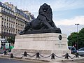
Lion de Belfort 2010.

Claude-Nicolas Ledoux's two pavilions that recreate the Barrière d'Enfer ( Monument historique )


Attractions
- In the middle of the square stands a copy of the Belfort Lion (original 1880 by Denfert-Rochereau in Belfort) on a high plinth .
- One of the listed metro entrances (built around 1900 by Hector Guimard in Art Nouveau style).
- Gare de Denfert-Rochereau station in the south-east, near Avenue René-Coty . The building, originally named Ligne de Sceaux because of its function as the terminal station of the railway line , was opened in 1846 and is the oldest existing station building in Paris. Today it serves as the main entrance to the Denfert-Rochereau RER station .
- The entrance to the catacombs is on the odd-numbered side at no.1, avenue du Colonel-Henri-Rol-Tanguy, next to building no.3, which until 2017 housed the Inspection générale des carrières .
- The two listed buildings No. 3 and 4 are the pavilions of the former Barrière d'Enfer , which were designed by the architect Claude-Nicolas Ledoux and are listed . This last part of the square had included the Place de la Barrière-d'Enfer , part of the Boulevards d'Enfer and Saint-Jacques and part of the Boulevards of Montrouge and Arcueil .
- The square is planted with trees and has three green spaces: Square de l'Abbé-Migne , Square Jacques-Antoine and Square Claude-Nicolas-Ledoux .

Monument à Raspail , in the Jacques-Antoine Square

Monument Ludovic Trarieux , by the sculptor Jean Boucher, in the Square Claude-Nicolas-Ledoux

Barrière d'Enfer pavilion
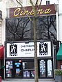
The Chaplin-Denfert cinema


Events
- Today, the square is often the starting or destination point for demonstration trains .
- Concerts are held here: Fête de la Musique .
Surroundings
In the vicinity of the square are u. a. the Montparnasse Cemetery , the Paris Observatory and the Cartier Foundation .
Literary mention
- The Barrière d'enfer is described in Victor Hugo's novel Les Misérables and forms the setting for the third image in Puccini's opera La Bohème .
- Stanislas Kraland: Paris: Les lieux secrets de l'Occupation. France 2016, 65 min (German version of ZDF from 2018 - also online, under the title Paris under the swastika - Terror, Resistance, Liberation . The last third of the film shows historical recordings of the command center from 1944)
- The first scene in the third act of Puccini's opera La Bohème takes place here .
Individual notes
- ↑ cf. z. B .: The wretches of Victor Hugo
- ↑ Gilles Thomas and Alain Clément, Atlas du Paris souterrain, Parigramme , 2001, 193 pages, ISBN 2840961911
- ^ Leparisien: Le pari gagné de Rol-Tanguy
- ↑ Entry no. PA00086609 in the Base Mérimée of the French Ministry of Culture (French)
- ↑ a b Entry no. PA75140009 in the Base Mérimée of the French Ministry of Culture (French)
Coordinates: 48 ° 50 ' N , 2 ° 20' E