
Place Saint-Michel
| Place Saint-Michel | |
|---|---|
| location | |
| Arrondissement | 5th , 6th |
| quarter | Sorbonne Monnaie |
| Beginning | 29, Quai Saint-Michel 1, Quai des Grands-Augustins |
| The End | 1, Boulevard Saint-Michel 1, Place Saint-André-des-Arts |
| morphology | |
| history | |
| Emergence | 1855 ( Déclaration d'utilité publique ) |
| designation | 1864 |
| Coding | |
| Paris | 8932 |

The Place Saint-Michel is a square in the Paris Latin Quarter on the border of the Quartier de la Sorbonne des 5th and the Quartier de la Monnaie in the 6th arrondissement of the French capital.
Until 1850 there was a square of the same name further south , which disappeared when the Boulevard Saint-Michel was built .
location
Located on the Rive Gauche directly on the left bank of the Seine , the square forms the intersection of the Pont Saint-Michel – Boulevard Saint-Michel and Quai des Grands Augustins – Quai Saint-Michel streets. In addition, the Rue Danton and the Rue de la Huchette go from there.
Under the square and Rue Danton is the station Saint-Michel of the metro line ![]() , the station Saint-Michel - Notre-Dame hold RER trains of the lines
, the station Saint-Michel - Notre-Dame hold RER trains of the lines ![]() and
and ![]() . The square can also be reached by bus routes 21, 24, 27, 38, 85, 96 and OpenTour .
. The square can also be reached by bus routes 21, 24, 27, 38, 85, 96 and OpenTour .
Surname
The square owes its name to the Pont Saint-Michel bridge , at the southern end of which it lies. Its name comes from the neighborhood of the Saint Michel du Palais church, which was destroyed in 1784, on the Île de la Cité in the 1st arrondissement .
history
Place Saint-Michel was built in 1855 under the reign of Napoleon III. as part of the construction of the Boulevard Saint-Michel. The construction of this square resulted in the disappearance of the Place du Pont-Saint-Michel , parts of the Rue Saint-André des Arts and Rue de l'Hirondelle and the Quai des Grands Augustins . The 14th century Pont Saint-Michel was renovated along with the square.
The famous fountain on the south side of the square, the Fontaine Saint-Michel , was created in 1860 by Gabriel Davioud . The square was officially named in 1864.
In August 1944, Place Saint-Michel was the scene of fighting between supporters of the French Resistance and the German occupiers , which ended with the liberation of Paris by Allied forces on August 25 and 26, 1944.

Square, bridge and Fontaine Saint-Michel on an engraving (late 19th century)
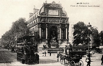
Fontaine Saint-Michel and trams powered by compressed air (around 1900)

Destruction of a sewer during the construction of the metro (1906)


Infrastructure and Outlook

On 28 May 1900, the station Saint-Michel was - Notre Dame opened since 1979, this station serves as a stop on the line C of the S-Bahn -like speed railway network Réseau express régional d'Ile-de-France (RER). In 1988 a station for the RER line B was added at a right angle . The Saint-Michel metro station, built using the caisson method , went into operation on January 9, 1910.
In addition to boutiques, cinemas, cafés and restaurants, there are numerous bookstores around Place Saint-Michel, including several shops in the traditional Parisian bookstore Gibert Jeune . The square offers a view of the buildings of the Île de la Cité such as the Palais de Justice , the Police Prefecture and the Notre-Dame de Paris Cathedral .
See also
Web links
Individual proof
- ↑ Saint Michel du Palais, une église proche du Palais de la Cité, servit pour le baptême des princes de France at histoires-de-paris.fr, accessed on December 15, 2019
- ^ Avril Frères, Boulevard de Sébastopol (rive gauche). Partie comprise entre les rues Saint-André-des-Arts et Serpente. Plan parcellaire , 1856 ( to be found here )
- ↑ Decree of August 19, 1864 ( read )
- ↑ Robert Gauthier, student and volunteer with the FFI , died on August 21, 1944 at the age of 21 in the struggle for the liberation of Paris . Raymond Boisson (1915–1944), head of the 2e groupe du corps franc des RG and the Jeux de la préfecture de police , fell in front of house no. 13 on August 20, 1944 at the age of 29 . The next day, the Gardien de Paix Joseph Lahuec fell at the same place .
Coordinates: 48 ° 51 '12 " N , 2 ° 20' 38" E