
Uetliberg planetary path

_IMG_6044.JPG)

The Uetliberg – Felsenegg planet trail is a hiking trail in the canton of Zurich on the Albis . The path leads from the station Uetliberg the Uetlibergbahn after season, Anna Castle, above the case grapeshot over Mädikon station Felsenegg the Luftseilbahn Adliswil-Felsenegg , about Felsenegg to Buchenegg . The duration of the hike is around two hours.
The trail was designed by Arnold von Rotz and opened on April 26, 1979. The patronage was taken over by the Astronomical Society Urania Zurich .
concept
The path is laid out on a scale of 1: 1 billion and thus offers a clear representation of the sizes and distances in the solar system . One meter of the model corresponds to one million kilometers in reality. The planetary path includes not only the planets Mercury , Venus , Earth , Mars , Jupiter , Saturn , Uranus and Neptune , but also the dwarf planets Ceres and Pluto .
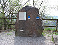
The planet models are attached to boulders on the Linth or Reuss glacier along the way . The smaller planet models were cast in glass and set into a niche in the boulder, the larger ones attached to the top of the boulder. A board on each planet provides information about its position in the solar system and additional information such as the equatorial diameter, rotational speed, orbital speed, orbit circumference and the like. As a model of the sun , a yellow sphere with a diameter of 1.39 meters was placed on a pole, which can be seen clearly from the first planetary models .
Dwarf planet Pluto is represented with three stations because of its strongly elliptical orbit: The first position corresponds to the perihelion , while it lies ahead of Neptune. The second position at Felsenegg corresponds to the mean distance and the third station near Buchenegg corresponds to the aphelion .
The closest star, Proxima Centauri , would be around 40'113 kilometers away on the same scale (for comparison: the circumference of the earth is around 40'030 kilometers).
Foundling species
| number | Star | Rock type | origin | Location |
|---|---|---|---|---|
| - | Sun | Coarse-grained sandstone | Middle Reuss Valley | Reuss Valley ( Reuss Glacier ) |
| 1 | Sun | Chlorite gneiss with quartz vein | Aarmassiv | Reuss Valley (Reuss Glacier) |
| 2 | Mercury | Verrucano | Glarnerland | Sihltal ( Linth glacier ) |
| 3 | Venus | Malmkalk | Lower Glarnerland | Sihltal (Linth glacier) |
| 4th | earth | Verrucano | Glarnerland | Albisgrat (Linth Glacier) |
| 5 | Mars | Granite with aplit passages | Aarmassiv | Reuss Valley (Reuss Glacier) |
| 6th | Ceres | Verrucano | Glarnerland | Sihltal (Linth glacier) |
| 7th | Jupiter | Granite porphyry | Schächentaler Windgallen | Reuss Valley (Reuss Glacier) |
| 8th | Saturn | Verrucano | Glarnerland | Sihltal (Linth glacier) |
| 9 | Uranus | Triassic sandstone | Middle Reuss Valley | Reuss Valley (Reuss Glacier) |
| 10 | Pluto (near the Sun) | Helvetic pebble | Lower Glarnerland | Sihltal (Linth glacier) |
| 11 | Neptune | Granite gneiss | Aarmassiv | Reuss Valley (Reuss Glacier) |
| 12 | Pluto | Verrucano | Glarnerland | Pfannenstiel (Linth Glacier) |
| - | Pluto | Verrucano | Glarnerland | Sihltal (Linth glacier) |
| 13 | Pluto (distance from the sun) | Molasse sandstone | Upper Sihl valley | Sihltal (Linth glacier) |
gallery

Sun model with two Reuss glacier boulders
Linth glacier boulder with a niche for the earth and the moon

Venus model in a Malmkalk boulder

Model of Neptune with a view of the Uetliberg


Web links
Individual evidence
- ^ Arnold von Rotz: Planet path at the Uetliberg Association; Retrieved April 23, 2010
Coordinates: 47 ° 21 ′ 6 " N , 8 ° 29 ′ 19" E ; CH1903: 679.34 thousand / 245,078