
Felsenegg
| Felsenegg | ||
|---|---|---|
 The Felsenegg on the Albisgrat |
||
| height | 810 m above sea level M. | |
| location | Canton of Zurich , Switzerland | |
| Mountains | Albiskette | |
| Dominance | 1 km → Stigberg | |
| Notch height | 21 m ↓ Restaurant Felsenegg | |
| Coordinates | 680 881 / 240217 | |
|
||

The Felsenegg ( 810 m ) is a lookout point on the Albis chain and the mountain station of the Adliswil – Felsenegg aerial cableway southwest of Zurich .
The Albis is one of the most important local recreation and hiking areas in the greater Zurich area. Via the Felsenegg, the hiking trail from Uetliberg leads along the Albis ridge in an easterly direction to the Albis Pass , starting with the Uetliberg – Felsenegg planet trail . From Adliswil , a steep forest path built between 1908 and 1912 leads up to Felsenegg.
The 73 m high radio tower Felsenegg-Girstel of Swisscom is visible from afar and is around 300 m from the top station of the Felseneggbahn cable car ▼ . The tower was built in 1959 to broadcast radio and television programs in the region. Skyguide has been operating a radio receiving station there since 2005 .

Transmission tower (seen from Adliswil)
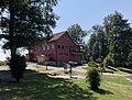
Felsenegg restaurant

Footpath from Adliswil to the Felsenegg


Digital radio ( DAB )
DAB is broadcast in vertical polarization and in single-frequency mode with other transmitters.
| block | Programs |
ERP (in kW) |
Antenna pattern round (ND), directional (D) |
Single frequency network (SFN) |
|---|---|---|---|---|
| 9D DIG D04 SUI0002C |
DAB block from DIGRIS:
|
0.3 | ND |
|
Web links
- Website Gasthaus Felsenegg with u. a. two webcams with a view from the Felsenegg