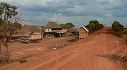
Santa Teresa del Yata pontoon
| Puerto Teresa Río Yata | ||
|---|---|---|
 Puerto Teresa Río Yata |
||
| Basic data | ||
| Residents (state) | 55 pop. (2012 census) | |
| height | 162 m | |
| Post Code | 08-0303-0101-0001 | |
| Telephone code | (+591) | |
| Coordinates | 13 ° 27 ′ S , 66 ° 36 ′ W | |
|
|
||
| politics | ||
| Department | Beni | |
| province | Ballivián Province | |
| climate | ||
 Climate diagram Rurrenabaque |
||
Santa Teresa del Yata (also: Puerto Teresa Río Yata ) is a town in the Beni department in the South American Andean state of Bolivia .
Location in the vicinity
Santa Teresa del Yata is a village in the district ( Bolivian : Municipio ) Santa Rosa in the province of Ballivián . The place is located at an altitude of 162 m on the left bank of the Río Yata , which flows here in an easterly direction and flows 900 kilometers downstream into the Río Mamoré . About fifty kilometers from Santa Teresa in a south-westerly direction near the town of El Triunfo there is a series of lakes, the largest of which is Lake Rogagua , a popular destination for tourists in the region, at 155 square kilometers .
geography
Santa Teresa del Yata is located in the Bolivian part of the Amazon basin east of the country's mountain ranges in a year-round humid climate.
The annual average temperature of the region is 26 ° C (see climate diagram Rurrenabaque) and fluctuates only marginally between 23 ° C in June and July and a good 27 ° C from October to December. The annual precipitation is almost 2000 mm, with a pronounced rainy season from December to March with 200 to 300 mm monthly precipitation and the lowest monthly values just under 100 mm from July to September.
Transport network
To the southeast of Santa Teresa del Yata and 561 kilometers by road is Trinidad , the capital of the department.
From Trinidad, the largely unpaved road Ruta 3 leads in a south-westerly direction via San Ignacio de Moxos and San Borja to Yucumo . From there the Ruta 8 leads over 99 kilometers to the northwest to Rurrenabaque, from there further in a northeast direction for another 97 kilometers via Reyes to Santa Rosa de Yacuma . From there it is another 84 kilometers in a north-easterly direction to the Río Yata, which she crosses on a newly built bridge at Santa Teresa del Yata .
In its extension, the road reaches the city of Guayaramerín on the Río Mamoré on the border with Brazil after a further 415 kilometers in the northeastern part of the country .
population
The population of the village has decreased drastically in the past two decades:
| year | Residents | source |
|---|---|---|
| 1992 | 188 | census |
| 2001 | 252 | census |
| 2012 | 55 | census |
Individual evidence
- ^ INE - Instituto Nacional de Estadística Bolivia 1992
- ^ INE - Instituto Nacional de Estadística Bolivia 2001
- ↑ INE - Instituto Nacional de Estadística Bolivia 2012 ( Memento of the original from July 22, 2011 in the Internet Archive ) Info: The archive link has been inserted automatically and has not yet been checked. Please check the original and archive link according to the instructions and then remove this notice.
Web links
- Las Petas region - Relief map 1: 250,000 (PDF; 8.11 MB)
- Yata region - topographic map 1: 100,000 (PDF; 4.5 MB)
- Municipio Santa Rosa de Yacuma - General Maps No. 80303
- Municipio Santa Rosa de Yacuma - detailed map and population data (PDF; 2.71 MB) ( Spanish )
- Departamento Beni - social data of the municipalities (PDF; 3.82 MB) ( Spanish )
