
Porta Claudia
Coordinates: 47 ° 23 '45.8 " N , 11 ° 15' 54.4" E


The Porta Claudia is a former fortification at the narrow point of the Scharnitz Pass in the Isar Valley near Scharnitz ( Tyrol , Austria ), on the border with Germany near Mittenwald (Bavaria). At the Porta Claudia - more precisely on the Scharnitz Pass - the B 2 (Germany) and the B 177 (Austria) begin .
history

In 1632, Tyrol was given the right to build the border fortification Porta Claudia on the Scharnitz Pass on Werdenfels territory - i.e. on foreign territory - to protect against the advancing Swedes in the Thirty Years' War . The border with Tyrol ran about one kilometer south of Scharnitz since 1500.
The construction of the dam was commissioned by Claudia de 'Medici , Archduchess of Austria and Princess of Tyrol , as a fortification of the important transition from Bavaria to Tyrol , and named after her. In 1648 - when the French invaded Bavaria after their victory at the Battle of Zusmarshausen - a second bar was built a little further north. By contract of October 29, 1656, Scharnitz and the area around the Porta Claudia were then exchanged for an area strip around the Kienleithenkopf with the Karolingerhof and right of way into the Hinterautal. In 1670 the fortress was expanded and in 1703 it was occupied by raids in the wake of the Bavarian hype . The destruction caused by the detonation of the powder magazine by the Bavarian occupation was repaired soon afterwards. With the contract of May 28, 1766, the affiliation of Scharnitz and Porta Claudia to Tyrol was confirmed, as well as for an area strip "on a musket shot at all fortification works at that time against Mittenwald".
Goethe described the border in his travel report to Italy in 1786 as "closed with a wall that barred the valley and adjoins the mountains."
Siege of Porta Claudia 1805
During Napoléon's campaign against Austria in 1805 ( 3rd coalition war ), French troops under Marshal Michel Ney besieged the Scharnitz and Leutasch passes on the north side of Bavaria. Part of the Porta Claudia were not only the fortifications near Scharnitz, but also the Leutascher Schanz a few kilometers west at the beginning of the Leutasch Valley . Ruins of it can still be seen there today. The VI. French army corps with 8,000 to 9,000 men faced 2,200 Tyroleans at the time. Led by local Mittenwalders (Bavaria was on the side of Napoléon Bonaparte ), the French were able to unexpectedly hit the Austrians stationed at the Leutascher Schanz fortification on November 4, 1805 on the trail leading from Lautersee and Ferchensee to the side of Grünkopf ( 1587 m ) fall. This enabled them to conquer first the Leutascher Schanz and then via Seefeld also the Scharnitz Pass and thus advance into the Inn Valley and Innsbruck . As a result of this ruse, the trail leading past the Grünkopf was named Franzosensteig (as such it is also entered in today's hiking maps). Allegedly, when the troops invaded Leutasch, only one shot was fired from a cannon. The cannonball hit the Gasthaus zur Mühle , where the landlady still keeps it today. After the defeat of Austerlitz and the Peace of Pressburg between Austria and France on December 26, 1805, Austria had to cede the counties of Tyrol and Vorarlberg to Bavaria and Emperor Franz II had to recognize Napoléon as emperor.
Current condition
Nowadays, only walls up to 6 meters high have survived from Porta Claudia ( Scharnitz, a listed building ). The remains of the smaller Schanze ( Leutasch, under monument protection ) in Leutasch can be seen at the old customs office in Unterleutasch - Schanz .
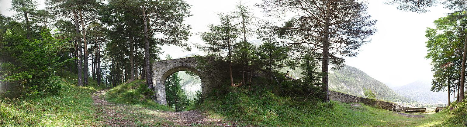
Defensive wall of the Porta Claudia on the western slope

literature
- Hans v. Zwiedineck-Südhorst: The Eastern Alps in the French Wars , Part II. The campaign of 1805 , p. 110 f., Magazine of the German and Austrian Alpine Club, year 1898, volume XXIX
- Carl Baur: The war in Tyrol during the campaign of 1809, with special reference to the Corps of the Supreme Count of Arco . With notes on the nature of the war in this mountainous country, along with a map of the theater of war. Munich 1812 ( Weblink, books.google.de ).
Individual evidence
- ^ Daniel-Erasmus Khan: The German State Borders - Legal-Historical Basics and Open Legal Issues. Mohr Siebeck 2004, p. 211 f. ISBN 9783161484032 Preview on Google Books
- ↑ Grafschaft Werdenfels - Scope and boundaries of the county: The Tyrolean border p. 16, in: Altbayern series I issue 9: Grafschaft Werdenfels, Komm. Für Bayerische Landesgeschichte, Munich 1955.
- ^ Johann Wolfgang von Goethe: Porta Claudia in the Gutenberg-DE Italian travel project, Chapter 3 on the Gutenberg-DE project
- ↑ The ruins of the Leutascher Schanz barrage at burgenwelt.org.
- ↑ Mountain tour description Obere Wettersteinspitze