Porto Nacional
| Município de Porto Nacional Porto Nacional |
|||
|---|---|---|---|
|
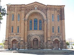
Nossa Senhora das Mercês cathedral in the listed historic center of Porto Nacional
|
|||
|
|
|||
| Coordinates | 10 ° 42 ′ S , 48 ° 25 ′ W | ||
 Location of the municipality in the state of Tocantins Location of the municipality in the state of Tocantins
|
|||
| Symbols | |||
|
|||
| founding | 1738 (first settlement) July 13, 1861 (becoming a town) |
||
| Basic data | |||
| Country | Brazil | ||
| State | Tocantins | ||
| ISO 3166-2 | BR-TO | ||
| Mesoregion | Ocidental do Tocantins (1989-2017) | ||
| Microregion | Porto Nacional (1989-2017) | ||
| Metropolitan area | Metropolitan area of Palmas | ||
| height | 212 m | ||
| climate | Aw, tropical | ||
| surface | 4,449.9 km² | ||
| Residents | 49,146 (2010) | ||
| density | 11 Ew. / km² | ||
| estimate | 53,010 Ew. (last: July 1, 2019) | ||
| Time zone | UTC −3 | ||
| Website | www.portonacional.to.gov.br (Brazilian Portuguese) | ||
| politics | |||
| City Prefect | Joaquim Maia (2017-2020) | ||
| Political party | PV | ||
| Culture | |||
| Patron saint | Nossa Senhora das Mercês | ||
| economy | |||
| GDP | 1,120,815 thousand R $ 21,618 R $ per person (2014) |
||
| HDI | 0.740 (2010) | ||
Porto Nacional , officially Município de Porto Nacional , is the fourth largest city in the Brazilian state of Tocantins in the Região Norte . It is 52 km from the capital of Palma . The population was estimated on July 1st, 2019 at 53,010 inhabitants, called Portuenses (Portuguese portuenses ), who live in an area of around 4450 km². The population density is 11 people per km².
The place used to be known as Porto Real , then Porto Imperial before it was renamed when the republic was founded. Until 1988 it belonged to the state of Goiás .
Porto Nacional is the seat of the Catholic diocese of the same name, Porto Nacional .
The human development index for cities, abbreviated HDI (Portuguese: IDH-M ), was at the low value of 0.424 in 1991 and at the high value of 0.740 in 2010.
climate
Hydrography
Porto Nacional is located in the Tocantins-Araguaia hydrographic basin.
literature
- Secretaria do Planejamento e Orçament (SEPLAN): Porto Nacional 2017 . Ed .: Governo do Estado do Tocantins (= Perfil Socioeconômico dos Municípios ). Palmas 2017 (Brazilian Portuguese, online [PDF]).
Web links
- City Prefecture website , Prefeitura Municipal (Brazilian Portuguese)
- City Council website , Câmara Municipal (Brazilian Portuguese)
Individual evidence
- ↑ a b c d Instituto Brasileiro de Geografia e Estatística (IBGE): Tocantins: Porto Nacional. Retrieved September 8, 2019 (Brazilian Portuguese).
- ↑ To breve histórico sobre a fundação e emancipação política de Porto Nacional. (No longer available online.) In: gov.br. www.portonacional.to.gov.br, archived from the original on January 21, 2018 ; Retrieved January 21, 2018 (Brazilian Portuguese). Info: The archive link was inserted automatically and has not yet been checked. Please check the original and archive link according to the instructions and then remove this notice.
- ^ Atlas do Desenvolvimento Humano do Brasil: Porto Nacional. Retrieved January 21, 2018 (Brazilian Portuguese).


