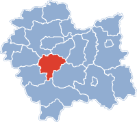
Powiat Myślenicki
| Powiat Myślenicki | |
|---|---|

|

|
| Basic data | |
| State : | Poland |
| Voivodeship : | Lesser Poland |
| County town : | Myślenice |
| Area : | 673.3 km 2 |
| Residents : | 118,459 (June 30, 2008) |
| License plate : |
KMY
|
| Circle structure | |
| Municipalities : | 0 |
| Urban and rural communities : | 3 |
| Rural communities : | 6th |
| Starostei (Stand:) | |
| Starost : | Adam Gumularz |
| Address: | M. Reja 13 32-400 Myślenice ul |
| Website : | www.powiat-myslenice.pl |
The Powiat Myślenicki is a powiat (district) of the Polish Lesser Poland Voivodeship . It lies in the central to western part of Lesser Poland and is surrounded by the Powiats Wieliczka , Bochnia , Limanowa , Nowy Targ , Sucha , Wadowice and Krakow .
Communities
The powiat comprises nine communities , which are divided into rural communities (gmina wiejska) and urban-and-rural communities (gmina miejsko-wiejska).
Urban-and-rural parishes
Rural communities
Web links
Individual evidence
- ↑ Główny Urząd Statystyczny, “LUDNOŚĆ. STAN I STRUKTURA W PRZEKROJU TERYTORIALNYM ", as of June 30, 2008 ( Memento from January 29, 2009 on WebCite )
