
Przyborów (Jeleśnia)
| Przyborów | |||
|---|---|---|---|

|
|
||
| Basic data | |||
| State : | Poland | ||
| Voivodeship : | Silesia | ||
| Powiat : | Żywiec | ||
| Gmina : | Jeleśnia | ||
| Geographic location : | 49 ° 37 ' N , 19 ° 23' E | ||
| Height : | 490-550 m npm | ||
| Residents : | 1793 (2008) | ||
| Postal code : | 34-340 Jeleśnia | ||
| Telephone code : | (+48) 33 | ||
| License plate : | SZY | ||

Przyborów is a village with a Schulzenamt of the municipality Jeleśnia in the Powiat Żywiecki of the Silesian Voivodeship in Poland .
geography
The place is on the river Koszarawa in the Saybuscher Beskids ( Beskid Żywiecki ), about 20 km southeast of Żywiec .
history
The place was probably founded in 1595 by the Wallachians on cleared land during the Saybusch rule .
During the first partition of Poland in 1772 the village became part of the new Kingdom of Galicia and Lodomeria of the Habsburg Empire (from 1804).
In 1918, after the end of the First World War and the collapse of the Austro-Hungarian monarchy, Przyborów became part of Poland. This was only interrupted by the occupation of Poland by the Wehrmacht in World War II . It then belonged to the district of Saybusch in the administrative district of Katowice in the province of Silesia (since 1941 province of Upper Silesia ).
The Roman Catholic parish was established in 1983.
From 1975 to 1998 Przyborów was part of the Bielsko-Biała Voivodeship .
Until 2001 the village belonged to the Koszarawa municipality .

Roman Catholic Church, built 1983–87
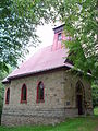
Chapel in the hamlet of Jabłonów, built in 1947


Individual evidence
- ↑ a b Sołectwo Przyborów
- ↑ Stanisław Figiel, Urszula Janicka-Krzywda, Piotr Krzywda, Wojciech W. Wiśniewski: Beskid Żywiecki. Przewodnik . Oficyna Wydawnicza "Rewasz", Pruszków 2006, ISBN 83-8918859-7 , p. 410-411 (Polish).
- ↑ Dz.U. 1975 no 17 poz. 92 (Polish) (PDF file; 783 kB)
