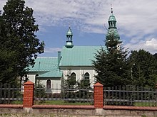
Krzyżowa (Jeleśnia)
| Krzyżowa | ||
|---|---|---|
 Help on coat of arms |
|
|
| Basic data | ||
| State : | Poland | |
| Voivodeship : | Silesia | |
| Powiat : | Żywiec | |
| Gmina : | Jeleśnia | |
| Geographic location : | 49 ° 35 ' N , 19 ° 21' E | |
| Height : | 480-550 m npm | |
| Residents : | 1300 (2010) | |
| Postal code : | 34-335 | |
| Telephone code : | (+48) 33 | |
| License plate : | SZY | |
Krzyżowa is a village with a Schulzenamt of the municipality Jeleśnia in the powiat Żywiecki of the Silesian Voivodeship in Poland .
geography
The place is located on the Krzyżówka brook in the Saybuscher Beskids ( Beskid Żywiecki ) on the road between Jeleśnia (in the north) and Korbielów (in the south).
history
Since 1467 the Saybusch rule belonged to the noble Komorowski family, who ran a settlement campaign. Jeleśnia and then Krzyżowa emerged along the so-called Kupferweg (to Orava ). The place was founded by Wallachians at the turn of the 15th century and was more rural.
During the first partition of Poland in 1772 the village became part of the new Kingdom of Galicia and Lodomeria of the Habsburg Empire (from 1804).
In 1918, after the end of the First World War and the collapse of the Austro-Hungarian monarchy, Krzyżowa came to Poland. This was only interrupted by the occupation of Poland by the Wehrmacht in World War II . It then belonged to the district of Saybusch in the administrative district of Katowice in the province of Silesia (since 1941 province of Upper Silesia ).
From 1975 to 1998 Krzyżowa belonged to the Bielsko-Biała Voivodeship .
traffic
Droga wojewódzka DW 945 runs through Krzyżowa. Kraków Airport is around 60 km away.
Individual evidence
- ^ Sołectwo Krzyżowa
- ↑ Stanisław Figiel, Urszula Janicka-Krzywda, Piotr Krzywda, Wojciech W. Wiśniewski: Beskid Żywiecki. Przewodnik . Oficyna Wydawnicza "Rewasz", Pruszków 2006, ISBN 83-8918859-7 , p. 374 (Polish).
- ↑ Dz.U. 1975 no 17 poz. 92 (Polish) (PDF file; 783 kB)


